
Haz una donación
Mapa topográfico Suffolk
Haga clic en el mapa para ver la altitud.
Haz una donación
Suffolk
The west of the county lies on more resistant Cretaceous chalk. This chalk is responsible for a sweeping tract of largely downland landscapes that stretches from Dorset in the south west to Dover in the south east and north through East Anglia to the Yorkshire Wolds. The chalk is less easily eroded so forms the only significant hills in the county. The highest point in the county is Great Wood Hill, with an elevation of 128 metres (420 ft).
Haz una donación
Acerca de este mapa
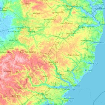
Nombre: Mapa topográfico Suffolk, altitud, relieve.
Lugar: Suffolk, England, United Kingdom (51.93176 0.33997 52.55022 1.76891)
Altitud media: 35 m
Altitud mínima: -4 m
Altitud máxima: 130 m
Haz una donación
Otros mapas topográficos
Haga clic en un mapa para ver su topografía, su altitud y su relieve.
Scafell Pike
United Kingdom > England > Cumberland
Scafell Pike (/ˈskɔːfɛl paɪk/) is a mountain in the Lake District region of Cumbria, England. It has an elevation of 978 metres (3,209 ft) above sea level, making it the highest and the most prominent mountain in England. The mountain is part of the Scafell massif, an extinct volcano, and is one of the…
Altitud media: 679 m
Ipswich
United Kingdom > England > Suffolk > Ipswich > Ipswich
Ipswich experiences an oceanic climate, like the rest of the British Isles, with a narrow range of temperature and rainfall spread evenly throughout the year. One of the two nearest for which data is available is East Bergholt, about 7 miles (11 km) south west of the town centre and at a similar elevation, and…
Altitud media: 30 m
Haz una donación
Burton-on-Trent
United Kingdom > England > Staffordshire > East Staffordshire
Burton is about 109 miles (175 km) north west of London, about 30 miles north east of Birmingham, the UK's second largest city and about 23 miles east of the county town Stafford. It is at the easternmost border of the county of Staffordshire with Derbyshire, its suburbs and the course of the River Trent…
Altitud media: 69 m
Haz una donación
Bebington
Bebington is on the eastern side of the Wirral Peninsula, approximately 10 km (6.2 mi) south-south-east of the Irish Sea at New Brighton, about 7.5 km (4.7 mi) east-north-east of the Dee Estuary at Gayton and less than 2 km (1.2 mi) west-north-west of the River Mersey at New Ferry. The area is situated at an…
Altitud media: 28 m
Haz una donación
Haz una donación
Sconce and Devon Park
United Kingdom > England > Nottinghamshire > Newark and Sherwood > Newark on Trent
Altitud media: 15 m
Haz una donación
Haz una donación
Lower Soudley
United Kingdom > England > Gloucestershire > Forest of Dean > Upper Soudley
Altitud media: 119 m
Haz una donación
Haz una donación
Haz una donación
Kitcher's Pond
United Kingdom > England > Hertfordshire > East Hertfordshire > Albury
Altitud media: 106 m
Freefolk
United Kingdom > England > Hampshire > Basingstoke and Deane > Whitchurch
Altitud media: 101 m
Haz una donación
Haz una donación
Haz una donación
Haz una donación
Haz una donación
Little Stanney Wood
United Kingdom > England > Cheshire West and Chester > Stoak > Little Stanney
Altitud media: 11 m
Haz una donación
Haz una donación
Haz una donación
Haz una donación
Juniper Hill
United Kingdom > England > Oxfordshire > Cherwell District > Cottisford
Altitud media: 126 m
Haz una donación
Haz una donación
Haz una donación
Haz una donación
Basingstoke
United Kingdom > England > Hampshire > Basingstoke and Deane
Situated in a valley through the Hampshire Downs at an average elevation of 88 metres (289 ft) Basingstoke is a major interchange between Reading, Newbury, Andover, Winchester, and Alton, and lies on the natural trade route between the southwest of England and London. The area had been something of an…
Altitud media: 107 m
Haz una donación
Haz una donación
Retford
United Kingdom > England > Nottinghamshire > Bassetlaw
In 1831, the Gas Works was built by James Malam and gaslights were lit in the town for the first time on 22 December 1831. The Square was lit by a cast iron light bearing five gas lamps at that time. The Gas Works became a target on 2 September 1916 when a German Zeppelin dropped 14 bombs on Retford. The…
Altitud media: 31 m
Haz una donación