
Haz una donación
Mapa topográfico Hoddesdon
Haga clic en el mapa para ver la altitud.
Haz una donación
Acerca de este mapa
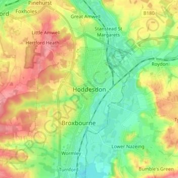
Nombre: Mapa topográfico Hoddesdon, altitud, relieve.
Altitud media: 54 m
Altitud mínima: 17 m
Altitud máxima: 105 m
Haz una donación
Otros mapas topográficos
Haga clic en un mapa para ver su topografía, su altitud y su relieve.
St Albans
United Kingdom > England > Hertfordshire
The borough consisted of the ancient parish of St Albans (also known as the Abbey parish) and parts of the parishes of St Michael and St Peter. The borough was reformed by the Municipal Corporations Act 1835 to become a municipal borough, and the boundary was adjusted to additionally include part of the parish…
Altitud media: 103 m
Kitcher's Pond
United Kingdom > England > Hertfordshire > East Hertfordshire > Albury
Altitud media: 106 m
Haz una donación
Haz una donación
Bishop's Stortford
United Kingdom > England > Hertfordshire > East Hertfordshire
Stortford, along with the rest of Britain, has a temperate maritime climate, with cool summers and mild winters. The nearest weather station for which averages and extremes are available is Stansted Airport, about 2+1⁄2 miles (4 kilometres) due east of Stortford's town centre. Located at an elevation of over…
Altitud media: 83 m
Haz una donación