
Haz una donación
Mapa topográfico Bramhall
Haga clic en el mapa para ver la altitud.
Haz una donación
Acerca de este mapa
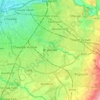
Nombre: Mapa topográfico Bramhall, altitud, relieve.
Altitud media: 82 m
Altitud mínima: 31 m
Altitud máxima: 171 m
Haz una donación
Otros mapas topográficos
Haga clic en un mapa para ver su topografía, su altitud y su relieve.
Coniston Water
United Kingdom > England > South Lakeland > Coniston > Dixon Ground
Coniston Water in the English county of Cumbria is the third-largest lake in the Lake District by volume (after Windermere and Ullswater), and the fifth-largest by area. It is five miles long by half a mile wide (8 km by 800 m), has a maximum depth of 184 feet (56 m), and covers an area of 1.89 square miles…
Altitud media: 186 m
Ramsgate
United Kingdom > England > Kent > Thanet
In 2017 Ramsgate was chosen as one of the first ten Heritage Action Zones (HAZ) by Historic England, with the aim of stimulating economic growth using Ramsgate's historic environment as a catalyst. Part of this project included a Historic Landscape Characterisation Study which assessed and mapped the patterns…
Altitud media: 25 m
Haz una donación
St Albans
United Kingdom > England > Hertfordshire
The borough consisted of the ancient parish of St Albans (also known as the Abbey parish) and parts of the parishes of St Michael and St Peter. The borough was reformed by the Municipal Corporations Act 1835 to become a municipal borough, and the boundary was adjusted to additionally include part of the parish…
Altitud media: 103 m
Haz una donación
Lake District National Park
The Lake District is a roughly circular upland massif, deeply dissected by a broadly radial pattern of major valleys which are largely the result of repeated glaciations over the last 2 million years. The apparent radial pattern is not from a central dome, but from an axial watershed extending from St Bees…
Altitud media: 206 m
Haz una donación
Haz una donación
Clungunford
United Kingdom > England > Shropshire
Clungunford lies at an elevation of between 130m and 145m above sea level.
Altitud media: 181 m
Haz una donación
Hertfordshire
Elevations are higher in the north and west, reaching more than 800 feet (240 m) in the Chilterns near Tring. The county centres on the headwaters and upper valleys of the rivers Lea and the Colne; both flow south and each is accompanied by a canal. Hertfordshire's undeveloped land is mainly agricultural and…
Altitud media: 82 m
Haz una donación
Ipswich
United Kingdom > England > Suffolk
Ipswich experiences an oceanic climate, like the rest of the British Isles, with a narrow range of temperature and rainfall spread evenly throughout the year. One of the two nearest for which data is available is East Bergholt, about 7 miles (11 km) south west of the town centre and at a similar elevation, and…
Altitud media: 29 m
Bakewell CP
United Kingdom > England > Derbyshire > Derbyshire Dales
The Manchester, Buxton, Matlock and Midlands Junction Railway opened Bakewell railway station in 1862, then became part of the Midland Railway and later of the LMS main line from London to Manchester. John Ruskin objected to what he saw as desecration of the Derbyshire countryside and to the fact that "every…
Altitud media: 194 m
Sconce and Devon Park
United Kingdom > England > Nottinghamshire > Newark and Sherwood > Newark on Trent
Altitud media: 15 m
Haz una donación
Haz una donación
Haz una donación
Suffolk
The west of the county lies on more resistant Cretaceous chalk. This chalk is responsible for a sweeping tract of largely downland landscapes that stretches from Dorset in the south west to Dover in the south east and north through East Anglia to the Yorkshire Wolds. The chalk is less easily eroded so forms…
Altitud media: 35 m
Haz una donación
Haz una donación
Kitcher's Pond
United Kingdom > England > Hertfordshire > East Hertfordshire > Albury
Altitud media: 106 m
Haz una donación
Haz una donación
Haz una donación
Exeter
United Kingdom > England > Devon
The city of Exeter was established on the eastern bank of the River Exe on a ridge of land backed by a steep hill. It is at this point that the Exe, having just been joined by the River Creedy, opens onto a wide flood plain and estuary which results in quite common flooding. Historically this was the lowest…
Altitud media: 56 m
Haz una donación
Haz una donación
Haz una donación
Haz una donación
Little Stanney Wood
United Kingdom > England > Cheshire West and Chester > Stoak > Little Stanney
Altitud media: 11 m
Haz una donación
Berkshire
United Kingdom > England > West Berkshire
All of the county is drained by the Thames. Berkshire divides into two topological (and associated geological) sections: east and west of Reading. North-east Berkshire has the low calciferous (limestone) m-shaped bends of the Thames south of which is a broader, clayey, gravelly former watery plain or belt from…
Altitud media: 100 m
Haz una donación
Haz una donación
Bournemouth
United Kingdom > England > Bournemouth, Christchurch and Poole > Kinson
Altitud media: 17 m
Haz una donación
Haz una donación
Bury St Edmunds
United Kingdom > England > Suffolk > West Suffolk
The name Bury is etymologically connected with borough, which has cognates in other Germanic languages such as German Burg 'fortress, castle' and Bereich '(defined) area' Old Norse borg 'wall, castle'; and Gothic baurg 'city'. They all derive from Proto-Germanic *burgs 'fortress'. This in turn derives from the…
Altitud media: 54 m
Haz una donación
Warlingham
United Kingdom > England > Surrey > Tandridge
Elevations vary from 110m AOD at Woldingham Road, at the southernmost point of the parish, with a gentle increase in height through the village along the main road heading to the southeast, to the highest elevation (199.6m) at Limpsfield Road.
Altitud media: 163 m
Haz una donación