
Haz una donación
Mapa topográfico Ellesmere
Haga clic en el mapa para ver la altitud.
Haz una donación
Acerca de este mapa
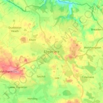
Nombre: Mapa topográfico Ellesmere, altitud, relieve.
Lugar: Ellesmere, Shropshire, England, SY12 0EQ, United Kingdom (52.86742 -2.93387 52.94742 -2.85387)
Altitud media: 94 m
Altitud mínima: 46 m
Altitud máxima: 155 m
Haz una donación
Otros mapas topográficos
Haga clic en un mapa para ver su topografía, su altitud y su relieve.
Clungunford
United Kingdom > England > Shropshire
Clungunford lies at an elevation of between 130m and 145m above sea level.
Altitud media: 181 m
Shrewsbury
United Kingdom > England > Shropshire > Shrewsbury
Shrewsbury is about 14 miles (23 km) west of Telford, 43 miles (69 km) west of Birmingham and the West Midlands Conurbation, and about 153 miles (246 km) north-west of the capital, London. More locally, the town is to the east of Welshpool, with Bridgnorth and Kidderminster to the south-east. The border with…
Altitud media: 69 m
Haz una donación