
Mapa topográfico Xichang City
Mapa interactivo
Haga clic en el mapa para ver la altitud.
Acerca de este mapa
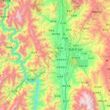
Nombre: Mapa topográfico Xichang City, altitud, relieve.
Lugar: Xichang City, Liangshan, Sichuan, 615000, China (27.54469 101.76800 28.18094 102.50767)
Altitud media: 2.319 m
Altitud mínima: 1.185 m
Altitud máxima: 4.195 m
Owing to its low latitude and high elevation, Xichang has a monsoon-influenced humid subtropical climate (Köppen Cwa) milder and far sunnier than the Sichuan Basin, with mild, very sunny and dry winters, and very warm, rainy summers. The monthly 24-hour average temperature ranges from 9.9 °C (49.8 °F) in January to 22.6 °C (72.7 °F) in July, and the annual mean is 17.15 °C (62.9 °F). Over 60% of the 1,025 mm (40.4 in) annual precipitation occurs from June to August. With monthly percent possible sunshine ranging from 36% in September to 72% in January, the city receives 2,367 hours of bright sunshine annually.
Otros mapas topográficos
Haga clic en un mapa para ver su topografía, su altitud y su relieve.
Mount Gongga
China > Sichuan > Luding County
Mount Gongga, Luding County, Kardze Tibetan Autonomous Prefecture, Sichuan, China
Altitud media: 6.496 m
Mengzhuiwan
China > Sichuan > Chenghua District > Mengzhuiwan
Mengzhuiwan, Chenghua District, Chengdu City, Sichuan, 610054, China
Altitud media: 502 m