
Mapa topográfico Liangshan
Mapa interactivo
Haga clic en el mapa para ver la altitud.
Acerca de este mapa
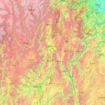
Nombre: Mapa topográfico Liangshan, altitud, relieve.
Lugar: Liangshan, Sichuan, China (26.04817 100.16675 29.30510 103.87517)
Altitud media: 2.439 m
Altitud mínima: 312 m
Altitud máxima: 5.740 m
Owing to its low latitude and high elevation, Liangshan has a mild climate. Under the Köppen system, the prefecture belongs to the humid subtropical zone (Köppen Cwa). Winters feature mild days and cool nights, while summers are very warm and humid. Monthly daily mean temperatures range from 9.6 °C (49.3 °F) in January to 22.3 °C (72.1 °F) in July. Unlike much of the province, which lies in the Sichuan Basin, humidity levels in winter are rather low, but like the rest of the province, rainfall is concentrated in the months of June through September, and the prefecture is virtually rainless in winter.
Otros mapas topográficos
Haga clic en un mapa para ver su topografía, su altitud y su relieve.
Mount Gongga
China > Sichuan > Luding County
Mount Gongga, Luding County, Kardze Tibetan Autonomous Prefecture, Sichuan, China
Altitud media: 6.496 m
Mengzhuiwan
China > Sichuan > Chenghua District > Mengzhuiwan
Mengzhuiwan, Chenghua District, Chengdu City, Sichuan, 610054, China
Altitud media: 502 m