
Haz una donación
Mapa topográfico Lough Neagh
Haga clic en el mapa para ver la altitud.
Haz una donación
Acerca de este mapa
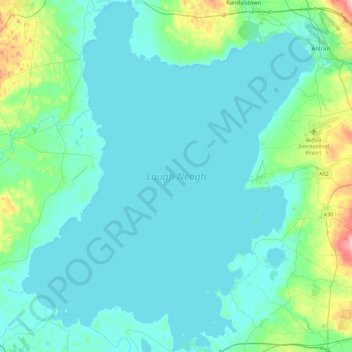
Nombre: Mapa topográfico Lough Neagh, altitud, relieve.
Lugar: Lough Neagh, County Antrim, Northern Ireland, United Kingdom (54.48594 -6.60911 54.75145 -6.22978)
Altitud media: 29 m
Altitud mínima: 8 m
Altitud máxima: 170 m
Haz una donación
Otros mapas topográficos
Haga clic en un mapa para ver su topografía, su altitud y su relieve.
Ballymoney
United Kingdom > Northern Ireland > County Antrim
In 1837, Lewis's Topographical Dictionary of Ireland, describes Ballymoney as "a market-town and post-town" containing 2,222 inhabitants (11,579 in the broader civil parish) with a long established linen market chiefly supplying the London market, and with "a very extensive trade ... in grain, butter, pork,…
Altitud media: 51 m
Haz una donación
Haz una donación
Haz una donación
Haz una donación
Loughgiel Millennium Centre
United Kingdom > Northern Ireland > County Antrim > Loughguile
Altitud media: 155 m
Magheramorne
United Kingdom > Northern Ireland > County Antrim > Craigstown Meadow
Altitud media: 32 m
Haz una donación
Haz una donación
Haz una donación
Haz una donación
Haz una donación
Haz una donación
Haz una donación
Lagan Navigation (Abandoned)
United Kingdom > Northern Ireland > County Antrim > Belfast
Altitud media: 29 m
Haz una donación
Haz una donación
Haz una donación
Haz una donación
Haz una donación
Haz una donación
Haz una donación
Haz una donación
Haz una donación
Haz una donación
Haz una donación
Haz una donación
Haz una donación
Haz una donación