
Haz una donación
Mapa topográfico Belfast
Haga clic en el mapa para ver la altitud.
Haz una donación
Acerca de este mapa
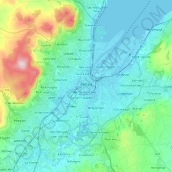
Nombre: Mapa topográfico Belfast, altitud, relieve.
Lugar: Belfast, County Antrim, Northern Ireland, United Kingdom (54.53061 -6.04548 54.65942 -5.80769)
Altitud media: 92 m
Altitud mínima: -3 m
Altitud máxima: 476 m
Haz una donación
Otros mapas topográficos
Haga clic en un mapa para ver su topografía, su altitud y su relieve.
Ballymoney
United Kingdom > Northern Ireland > County Antrim
In 1837, Lewis's Topographical Dictionary of Ireland, describes Ballymoney as "a market-town and post-town" containing 2,222 inhabitants (11,579 in the broader civil parish) with a long established linen market chiefly supplying the London market, and with "a very extensive trade ... in grain, butter, pork,…
Altitud media: 51 m
Haz una donación
Haz una donación
Haz una donación
Haz una donación
Haz una donación
Magheramorne
United Kingdom > Northern Ireland > County Antrim > Craigstown Meadow
Altitud media: 32 m
Haz una donación
Haz una donación
Haz una donación
Haz una donación
Shane's Castle Park
United Kingdom > Northern Ireland > County Antrim > Randalstown
Altitud media: 30 m
Haz una donación
Haz una donación
Haz una donación
Haz una donación
Haz una donación
Antrim and Newtownabbey District
United Kingdom > Northern Ireland > County Antrim
Altitud media: 97 m
Haz una donación
Haz una donación
Haz una donación
Haz una donación
Haz una donación
Haz una donación
Antrim and Newtownabbey District
United Kingdom > Northern Ireland > County Antrim
Altitud media: 97 m
Haz una donación
Haz una donación
Haz una donación
Haz una donación
Antrim and Newtownabbey District
United Kingdom > Northern Ireland > County Antrim
Altitud media: 97 m
Haz una donación