
Haz una donación
Mapa topográfico Ballymoney
Haga clic en el mapa para ver la altitud.
Haz una donación
Ballymoney
In 1837, Lewis's Topographical Dictionary of Ireland, describes Ballymoney as "a market-town and post-town" containing 2,222 inhabitants (11,579 in the broader civil parish) with a long established linen market chiefly supplying the London market, and with "a very extensive trade ... in grain, butter, pork, and general provisions". Transport was largely via the Bann. By 1860, the town was connected to both Belfast and Derry by rail.
Haz una donación
Acerca de este mapa
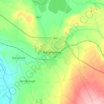
Nombre: Mapa topográfico Ballymoney, altitud, relieve.
Altitud media: 51 m
Altitud mínima: 0 m
Altitud máxima: 137 m
Haz una donación
Otros mapas topográficos
Haga clic en un mapa para ver su topografía, su altitud y su relieve.
Haz una donación
Loughgiel Millennium Centre
United Kingdom > Northern Ireland > County Antrim > Loughguile
Altitud media: 155 m
Haz una donación
Shane's Castle Park
United Kingdom > Northern Ireland > County Antrim > Randalstown
Altitud media: 30 m
Lagan Navigation (Abandoned)
United Kingdom > Northern Ireland > County Antrim > Belfast
Altitud media: 29 m
Haz una donación
Antrim and Newtownabbey District
United Kingdom > Northern Ireland > County Antrim
Altitud media: 97 m
Haz una donación
Haz una donación
Haz una donación
Antrim and Newtownabbey District
United Kingdom > Northern Ireland > County Antrim
Altitud media: 97 m
Haz una donación
Haz una donación
Haz una donación
Antrim and Newtownabbey District
United Kingdom > Northern Ireland > County Antrim
Altitud media: 97 m