
Mapa topográfico Vet River
Mapa interactivo
Haga clic en el mapa para ver la altitud.
Acerca de este mapa
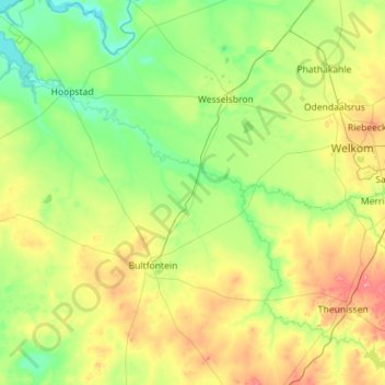
Nombre: Mapa topográfico Vet River, altitud, relieve.
Altitud media: 1.312 m
Altitud mínima: 1.225 m
Altitud máxima: 1.590 m
Otros mapas topográficos
Haga clic en un mapa para ver su topografía, su altitud y su relieve.
Harrismith
RSA > Free State > Harrismith
Harrismith, Thabo Mofutsanyana District Municipality, Free State, 9880, RSA
Altitud media: 1.655 m
Armenia Dam
RSA > Free State > Mantsopa Local Municipality
Armenia Dam, Hobhouse Street, Mantsopa Ward 1, Mantsopa Local Municipality, Thabo Mofutsanyana District Municipality, Free State, RSA
Altitud media: 1.535 m
Sterkfontein Dam Nature Reserve
RSA > Free State > Maluti-a-Phofung Local Municipality
Sterkfontein Dam Nature Reserve, Blesbuck, Maluti-a-Phofung Ward 6, Maluti-a-Phofung Local Municipality, Thabo Mofutsanyana District Municipality, Free State, RSA
Altitud media: 1.766 m
Dihlabeng Ward 20
RSA > Free State > Dihlabeng Local Municipality
Dihlabeng Ward 20, Dihlabeng Local Municipality, Thabo Mofutsanyana District Municipality, Free State, 9707, RSA
Altitud media: 1.975 m
Mangaung Ward 45
RSA > Free State > Bloemfontein
Mangaung Ward 45, Bloemfontein, Mangaung Metropolitan Municipality, Free State, RSA
Altitud media: 1.365 m
Brandfort
RSA > Free State > Masilonyana Local Municipality
Brandfort, Masilonyana Local Municipality, Lejweleputswa District Municipality, Free State, 9400, RSA
Altitud media: 1.404 m
Rustfontein Dam
RSA > Free State > Botshabelo
Rustfontein Dam, Botshabelo, Mangaung Metropolitan Municipality, Free State, RSA
Altitud media: 1.375 m
Setsoto Ward 11
RSA > Free State > Setsoto Local Municipality
Setsoto Ward 11, Setsoto Local Municipality, Thabo Mofutsanyana District Municipality, Free State, RSA
Altitud media: 1.574 m
Egmont Dam
RSA > Free State > Naledi Local Municipality
Egmont Dam, Naledi Local Municipality, Xhariep District Municipality, Free State, RSA
Altitud media: 1.501 m
Swartkrans
RSA > Free State > Dihlabeng Local Municipality
Swartkrans, Dihlabeng Local Municipality, Thabo Mofutsanyana District Municipality, Free State, RSA
Altitud media: 2.036 m
Ngwathe Ward 18
RSA > Free State > Ngwathe Local Municipality
Ngwathe Ward 18, Ngwathe Local Municipality, Fezile Dabi District Municipality, Free State, RSA
Altitud media: 1.443 m
Willem Pretorius Wildtuin
RSA > Free State > Setsoto Local Municipality
Willem Pretorius Wildtuin, Setsoto Ward 3, Setsoto Local Municipality, Thabo Mofutsanyana District Municipality, Free State, RSA
Altitud media: 1.371 m
Kalkfontein Dam
RSA > Free State > Letsemeng Local Municipality
Kalkfontein Dam, Letsemeng Local Municipality, Xhariep District Municipality, Free State, RSA
Altitud media: 1.234 m
Ngwathe Ward 13
RSA > Free State > Ngwathe Local Municipality
Ngwathe Ward 13, Ngwathe Local Municipality, Fezile Dabi District Municipality, Free State, RSA
Altitud media: 1.407 m
Renoster
RSA > Free State > Moqhaka Local Municipality
Renoster, Moqhaka Local Municipality, Fezile Dabi District Municipality, Free State, RSA
Altitud media: 1.356 m
Maluti-a-Phofung Ward 27
RSA > Free State > Maluti-a-Phofung Local Municipality
Maluti-a-Phofung Ward 27, Maluti-a-Phofung Local Municipality, Thabo Mofutsanyana District Municipality, Free State, RSA
Altitud media: 1.670 m
Dasklip
RSA > Free State > Mafube Local Municipality
Dasklip, R26, Mafube Ward 4, Mafube Local Municipality, Fezile Dabi District Municipality, Free State, RSA
Altitud media: 1.557 m
Mangaung Ward 19
RSA > Free State > Bloemfontein
Mangaung Ward 19, Bloemfontein, Mangaung Metropolitan Municipality, Free State, 9301, RSA
Altitud media: 1.407 m
Franklin Game Reserve
RSA > Free State > Bloemfontein
Franklin Game Reserve, Naval Hill 5, Mangaung Ward 21, Bloemfontein, Mangaung Metropolitan Municipality, Free State, 9300, RSA
Altitud media: 1.421 m
Metsimaholo Ward 14
RSA > Free State > Metsimaholo Local Municipality
Metsimaholo Ward 14, Metsimaholo Local Municipality, Fezile Dabi District Municipality, Free State, 1947, RSA
Altitud media: 1.459 m
Golden Gate Highlands National Park
RSA > Free State > Dihlabeng Local Municipality
Golden Gate Highlands National Park, Blesbok Loop, Dihlabeng Ward 20, Dihlabeng Local Municipality, Thabo Mofutsanyana District Municipality, Free State, RSA
Altitud media: 2.065 m
Maluti-a-Phofung Ward 20
RSA > Free State > Maluti-a-Phofung Local Municipality
Maluti-a-Phofung Ward 20, Maluti-a-Phofung Local Municipality, Thabo Mofutsanyana District Municipality, Free State, RSA
Altitud media: 2.228 m