
Mapa topográfico Ngwathe Ward 18
Mapa interactivo
Haga clic en el mapa para ver la altitud.
Acerca de este mapa
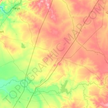
Nombre: Mapa topográfico Ngwathe Ward 18, altitud, relieve.
Altitud media: 1.443 m
Altitud mínima: 1.340 m
Altitud máxima: 1.575 m
Otros mapas topográficos
Haga clic en un mapa para ver su topografía, su altitud y su relieve.
Ngwathe Ward 13
RSA > Free State > Ngwathe Local Municipality
Ngwathe Ward 13, Ngwathe Local Municipality, Fezile Dabi District Municipality, Free State, RSA
Altitud media: 1.407 m