
Mapa topográfico Sterkfontein Dam Nature Reserve
Mapa interactivo
Haga clic en el mapa para ver la altitud.
Acerca de este mapa
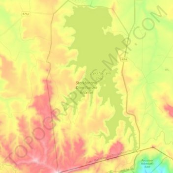
Nombre: Mapa topográfico Sterkfontein Dam Nature Reserve, altitud, relieve.
Altitud media: 1.766 m
Altitud mínima: 1.272 m
Altitud máxima: 2.282 m
Otros mapas topográficos
Haga clic en un mapa para ver su topografía, su altitud y su relieve.
Maluti-a-Phofung Ward 27
RSA > Free State > Maluti-a-Phofung Local Municipality
Maluti-a-Phofung Ward 27, Maluti-a-Phofung Local Municipality, Thabo Mofutsanyana District Municipality, Free State, RSA
Altitud media: 1.670 m
Maluti-a-Phofung Ward 20
RSA > Free State > Maluti-a-Phofung Local Municipality
Maluti-a-Phofung Ward 20, Maluti-a-Phofung Local Municipality, Thabo Mofutsanyana District Municipality, Free State, RSA
Altitud media: 2.228 m