
Mapa topográfico Bali
Mapa interactivo
Haga clic en el mapa para ver la altitud.
Acerca de este mapa
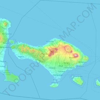
Nombre: Mapa topográfico Bali, altitud, relieve.
Lugar: Bali, Lesser Sunda Islands, Indonesia (-9.05023 114.41268 -7.46280 115.83242)
Altitud media: 88 m
Altitud mínima: -1 m
Altitud máxima: 2.917 m
Bali's central mountains include several peaks over 2,000 metres (6,600 feet) in elevation and active volcanoes such as Mount Batur. The highest is Mount Agung (3,031 m; 9,944 ft), known as the "mother mountain", which is an active volcano rated as one of the world's most likely sites for a massive eruption within the next 100 years. In late 2017 Mount Agung started erupting and large numbers of people were evacuated, temporarily closing the island's airport. Mountains range from centre to the eastern side, with Mount Agung the easternmost peak. Bali's volcanic nature has contributed to its exceptional fertility and its tall mountain ranges provide the high rainfall that supports the highly productive agriculture sector. South of the mountains is a broad, steadily descending area where most of Bali's large rice crop is grown. The northern side of the mountains slopes more steeply to the sea and is the main coffee-producing area of the island, along with rice, vegetables, and cattle. The longest river, Ayung River, flows approximately 75 km (47 mi) (see List of rivers of Bali).
Otros mapas topográficos
Haga clic en un mapa para ver su topografía, su altitud y su relieve.
Bitaran
Indonesia > Central Java > Klaten > Keprabon
Bitaran, Keprabon, Klaten, Central Java, Java, 57471, Indonesia
Altitud media: 170 m
Klampok
Indonesia > Central Java > Banjarnegara
Klampok, Banjarnegara, Central Java, Java, 53382, Indonesia
Altitud media: 54 m
gembong
Indonesia > Central Java > Pekalongan
gembong, Pekalongan, Central Java, Java, Indonesia
Altitud media: 737 m
Bukateja
Indonesia > Central Java > Purbalingga
Bukateja, Purbalingga, Central Java, Java, 53382, Indonesia
Altitud media: 51 m
Ciwidey
Indonesia > West Java > Bandung Regency
Ciwidey, Bandung Regency, West Java, Java, Indonesia
Altitud media: 1.188 m
Cleveland
Indonesia > Banten > Tangerang Regency > Salembaran Jati
Cleveland, Pantai Indah Kapuk 2, Salembaran Jati, Kosambi, Tangerang Regency, Banten, Java, Indonesia
Altitud media: 2 m
Temon
Indonesia > Special Region of Yogyakarta > Kulon Progo > Temonkulon
Temon, Temonkulon, Temon, Kulon Progo, Special Region of Yogyakarta, Java, 55654, Indonesia
Altitud media: 30 m
Calaca
Indonesia > North Sulawesi > Manado
Calaca, Manado, North Sulawesi, Sulawesi, 95122, Indonesia
Altitud media: 11 m
Sungai Satui
Indonesia > South Kalimantan > Tanah Bumbu
Sungai Satui, Tanah Bumbu, South Kalimantan, Kalimantan, Indonesia
Altitud media: 51 m
Gunung Satui
Indonesia > South Kalimantan > Banjar
Gunung Satui, Banjar, South Kalimantan, Kalimantan, Indonesia
Altitud media: 485 m
Tuapejat
Indonesia > West Sumatra > Tuapejat
Tuapejat, West Sumatra, 25700, Indonesia
Altitud media: 18 m
Barede Hill Sunrise
Indonesia > Central Java > Magelang > Tegalarum
Barede Hill Sunrise, Jalan Salaman - Mungkid, Tegalarum, Magelang, Central Java, 56553, Indonesia
Altitud media: 273 m
Karangrejo
Indonesia > Central Java > Magelang > Karangrejo
Karangrejo, Magelang, Central Java, 56553, Indonesia
Altitud media: 277 m
Pasirkaliki
Indonesia > West Java > Bandung > Pasirkaliki
Pasirkaliki, Cicendo, Bandung, West Java, 40171, Indonesia
Altitud media: 729 m
Rancabolang
Indonesia > West Java > Bandung > Rancabolang
Rancabolang, Gedebage, Bandung, West Java, Indonesia
Altitud media: 664 m
Boba
Indonesia > Central Sulawesi > Morowali Utara > Boba
Boba, Morowali Utara, Central Sulawesi, Indonesia
Altitud media: 363 m
Kulon Progo
Indonesia > Special Region of Yogyakarta
Kulon Progo, Special Region of Yogyakarta, Java, Indonesia
Altitud media: 139 m
Morowali Utara
Morowali Utara, Central Sulawesi, 94971, Indonesia
Altitud media: 708 m
Gunung Bohong
Indonesia > West Java > Cimahi
Gunung Bohong, Cimahi, West Java, 40524, Indonesia
Altitud media: 733 m
Taman Flora
Taman Flora, RW 08, Baratajaya, Gubeng, Surabaya, 60284, Indonesia
Altitud media: 5 m