
Mapa topográfico Banda Aceh
Mapa interactivo
Haga clic en el mapa para ver la altitud.
Acerca de este mapa
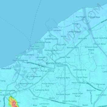
Nombre: Mapa topográfico Banda Aceh, altitud, relieve.
Lugar: Banda Aceh, Aceh, Sumatra, Indonesia (5.51639 95.27506 5.60724 95.37777)
Altitud media: 5 m
Altitud mínima: -3 m
Altitud máxima: 220 m
Banda Aceh (Acehnese: Banda Acèh, Jawoë: بند اچيه) is the capital and largest city in the province of Aceh, Indonesia. It is located on the island of Sumatra and has an elevation of 35 meters (115 feet). The city covers an area of 61.36 square kilometers (23.69 sq mi) and had a population of 223,446 people at the 2010 Census, rising to 252,899 at the 2020 Census. The official estimate as at mid 2023 was 261,969 (comprising 131,651 males and 130,318 females).
Otros mapas topográficos
Haga clic en un mapa para ver su topografía, su altitud y su relieve.
Gunung Babahrot
Gunung Babahrot, Babah Rot, Aceh Barat Daya, Aceh, Indonesia
Altitud media: 157 m
Gunung Bandahara
Gunung Bandahara, Putri Betung, Gayo Lues, Aceh, Indonesia
Altitud media: 2.634 m
Gunung Mugajah
Gunung Mugajah, Serbajadi, Aceh Timur, Aceh, Indonesia
Altitud media: 2.189 m