
Mapa topográfico Pontianak
Mapa interactivo
Haga clic en el mapa para ver la altitud.
Acerca de este mapa
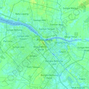
Nombre: Mapa topográfico Pontianak, altitud, relieve.
Lugar: Pontianak, West Kalimantan, Indonesia (-0.09819 109.27417 0.03812 109.38535)
Altitud media: 4 m
Altitud mínima: -7 m
Altitud máxima: 9 m
Pontianak lies on the equator at a height ranging from 0.1 to 1.5 meters above sea level. It is divided into three parts by the Kapuas Besar and its major tributaries - the Kapuas Kecil and Landak rivers. The city lies on flat land in the delta of the Kapuas River with a ground level elevation ranging from 0.1 to 1.9 meters above sea level.
Otros mapas topográficos
Haga clic en un mapa para ver su topografía, su altitud y su relieve.
Tapang Pulau
Indonesia > West Kalimantan > Tapang Pulau
Tapang Pulau, Belitang Hilir, Sekadau, West Kalimantan, Indonesia
Altitud media: 24 m
Kapuas River
Kapuas River, West Kalimantan, 78611, Indonesia
Altitud media: 141 m