
Mapa topográfico St Albans
Mapa interactivo
Haga clic en el mapa para ver la altitud.
Acerca de este mapa
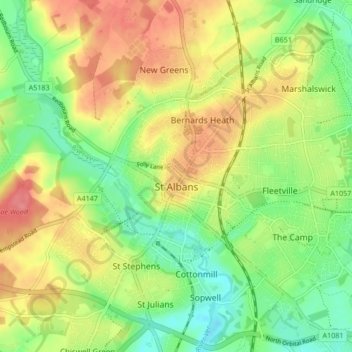
Nombre: Mapa topográfico St Albans, altitud, relieve.
Lugar: St Albans, Hertfordshire, England, United Kingdom (51.72913 -0.37529 51.78007 -0.29102)
Altitud media: 103 m
Altitud mínima: 69 m
Altitud máxima: 141 m
The borough consisted of the ancient parish of St Albans (also known as the Abbey parish) and parts of the parishes of St Michael and St Peter. The borough was reformed by the Municipal Corporations Act 1835 to become a municipal borough, and the boundary was adjusted to additionally include part of the parish of St Stephen. On 28 August 1877 the borough gained city status, following the elevation of St Albans Abbey to become a cathedral. The boundary was also adjusted in 1877 to include part of the parish of Sandridge.
Otros mapas topográficos
Haga clic en un mapa para ver su topografía, su altitud y su relieve.
Newnham
United Kingdom > England > Hertfordshire > North Hertfordshire
Newnham, North Hertfordshire, Hertfordshire, England, United Kingdom
Altitud media: 69 m
Sandridge
United Kingdom > England > Hertfordshire > St Albans
Sandridge, St Albans, Hertfordshire, England, United Kingdom
Altitud media: 105 m
Borehamwood
United Kingdom > England > Hertfordshire > Hertsmere
Borehamwood, Hertsmere, Hertfordshire, England, WD6 5HL, United Kingdom
Altitud media: 104 m
Sandon
United Kingdom > England > Hertfordshire > North Hertfordshire
Sandon, North Hertfordshire, Hertfordshire, England, United Kingdom
Altitud media: 130 m
Frogmore
United Kingdom > England > Hertfordshire > St Albans
Frogmore, St Albans, Hertfordshire, England, AL2 2LS, United Kingdom
Altitud media: 80 m
Harpenden
United Kingdom > England > Hertfordshire > St Albans > Harpenden
Harpenden, St Albans, Hertfordshire, England, United Kingdom
Altitud media: 119 m
Dacorum
United Kingdom > England > Hertfordshire > Dacorum
Dacorum, Hertfordshire, East of England, England, United Kingdom
Altitud media: 142 m
Kings Langley
United Kingdom > England > Hertfordshire > Dacorum
Kings Langley, Dacorum, Hertfordshire, England, United Kingdom
Altitud media: 111 m
Garston
United Kingdom > England > Hertfordshire > Watford > Garston
Garston, Watford, Hertfordshire, East of England, England, WD25 9JT, United Kingdom
Altitud media: 83 m
Potters Bar
United Kingdom > England > Hertfordshire > Hertsmere
Potters Bar, Hertsmere, Hertfordshire, England, EN6 1QG, United Kingdom
Altitud media: 98 m
Bishop's Stortford
United Kingdom > England > Hertfordshire > East Hertfordshire
Bishop's Stortford, East Hertfordshire, Hertfordshire, England, United Kingdom
Altitud media: 83 m
St Albans
United Kingdom > England > Hertfordshire > St Albans
St Albans, Hertfordshire, East of England, England, United Kingdom
Altitud media: 107 m
Hoddesdon
United Kingdom > England > Hertfordshire
Hoddesdon, Broxbourne, Hertfordshire, England, EN11 8UD, United Kingdom
Altitud media: 54 m
Gilston
United Kingdom > England > Hertfordshire > East Hertfordshire > Gilston
Gilston, East Hertfordshire, Hertfordshire, England, United Kingdom
Altitud media: 59 m
Wakeley
United Kingdom > England > Hertfordshire > East Hertfordshire > Buntingford > Westmill > Wakeley
Wakeley, Westmill, Buntingford, East Hertfordshire, Hertfordshire, East of England, England, SG9 9NH, United Kingdom
Altitud media: 121 m