
Mapa topográfico St Albans
Mapa interactivo
Haga clic en el mapa para ver la altitud.
Acerca de este mapa
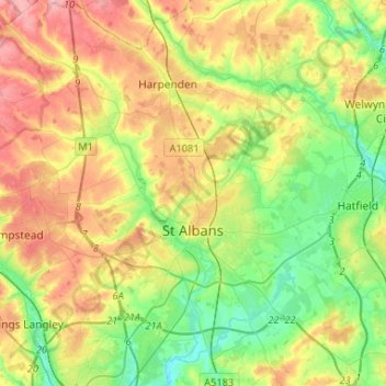
Nombre: Mapa topográfico St Albans, altitud, relieve.
Altitud media: 107 m
Altitud mínima: 58 m
Altitud máxima: 175 m
St Albans was an ancient borough created following the dissolution of the monastery in 1539. It consisted of the ancient parish of St Albans (also known as the Abbey parish) and parts of St Michael and St Peter. The municipal corporation was reformed by the Municipal Corporations Act 1835 and the boundary was adjusted to additionally include part of the parish of St Stephen. In 1887 the borough gained city status, following the elevation of St Albans Abbey to cathedral, and the boundary was adjusted to include part of the parish of Sandridge.
Otros mapas topográficos
Haga clic en un mapa para ver su topografía, su altitud y su relieve.
Sandridge
United Kingdom > England > Hertfordshire > St Albans
Sandridge, St Albans, Hertfordshire, England, United Kingdom
Altitud media: 105 m
Frogmore
United Kingdom > England > Hertfordshire > St Albans
Frogmore, St Albans, Hertfordshire, England, AL2 2LS, United Kingdom
Altitud media: 80 m
Harpenden
United Kingdom > England > Hertfordshire > St Albans > Harpenden
Harpenden, St Albans, Hertfordshire, England, United Kingdom
Altitud media: 119 m