
Haz una donación
Mapa topográfico Crawley
Haga clic en el mapa para ver la altitud.
Haz una donación
Crawley
Crawley lies within the Sussex Weald, an area of highly variable terrain so that many microclimates of frost hollows, sun traps and windswept hilltops will be encountered over a short distance. During calm, clear periods of weather this allows for some interesting temperature variations, although most of the time, when mobile westerly airstreams persist, the weather is typically Oceanic like the rest of the British Isles. Gatwick is the nearest weather station that publishes long-term averages that give an accurate description of the climate of the Crawley area, although more recently the Met Office has also published data for its nearby weather station at Charlwood. Both weather stations are about 3 miles north of Crawley town centre and at similar altitudes.
Haz una donación
Acerca de este mapa
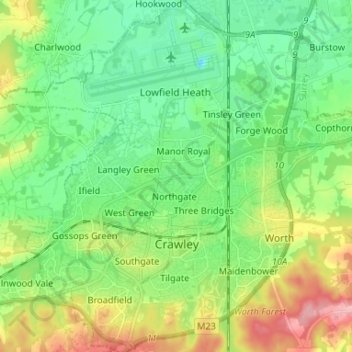
Nombre: Mapa topográfico Crawley, altitud, relieve.
Lugar: Crawley, West Sussex, England, United Kingdom (51.08481 -0.25563 51.16730 -0.13298)
Altitud media: 80 m
Altitud mínima: 39 m
Altitud máxima: 165 m
Haz una donación
Otros mapas topográficos
Haga clic en un mapa para ver su topografía, su altitud y su relieve.
Haz una donación
Brook Street
United Kingdom > England > West Sussex > Mid Sussex > Whitemans Green
Altitud media: 76 m
Haz una donación
Haz una donación
Washington Common
United Kingdom > England > West Sussex > Storrington > Washington
Altitud media: 61 m
Haz una donación
Haz una donación
Haz una donación
Batchelors Farm Nature Conservation Site
United Kingdom > England > West Sussex > Mid Sussex District > Burgess Hill
Altitud media: 49 m
Haz una donación
Haz una donación
Haz una donación
Henry Burt Wood
United Kingdom > England > West Sussex > Mid Sussex > Burgess Hill
Altitud media: 39 m
Haz una donación
Haz una donación
Haz una donación
Haz una donación
Haz una donación
Haz una donación
Haz una donación
Haz una donación
Haz una donación
Haz una donación
Haz una donación
Haz una donación
Haz una donación
Haz una donación
Haz una donación
Haz una donación