
Haz una donación
Mapa topográfico Prinsted
Haga clic en el mapa para ver la altitud.
Haz una donación
Acerca de este mapa
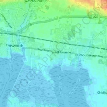
Nombre: Mapa topográfico Prinsted, altitud, relieve.
Altitud media: 6 m
Altitud mínima: -4 m
Altitud máxima: 36 m
Haz una donación
Otros mapas topográficos
Haga clic en un mapa para ver su topografía, su altitud y su relieve.
Haz una donación
Selsey
United Kingdom > England > West Sussex > Chichester
A study published by Princeton University and McGill University, in 2020, concluded that the Manhood Peninsula is at particularly high risk of flooding as its topography is less than 5 metres (16 ft) above the current mean sea level and that by 2100 Selsey will be subject to permanent inundation.
Altitud media: 1 m
West Wittering
United Kingdom > England > West Sussex > Chichester > West Wittering
Altitud media: 2 m
Haz una donación
Haz una donación
Harting
United Kingdom > England > West Sussex > Chichester > South Harting
Because of its elevation Beacon Hill, just to the east of Harting Down, hosted a station in the shutter telegraph chain, from 1796 to 1816, which connected the Admiralty in London to its naval ships in Portsmouth and Plymouth. This was replaced in 1822 by a semaphore station which operated on a slightly…
Altitud media: 101 m
Haz una donación
Haz una donación
Haz una donación
Haz una donación
Haz una donación
Upwaltham
United Kingdom > England > West Sussex > Chichester
The Skytrain was from the 27th Transport Group. On 11 February 1945 it was on a flight from Paris–Le Bourget Airport to RAF Grove in Berkshire. It crossed the Sussex coast about 1125 hrs at an altitude of only 300 to 400 feet (91 to 122 m). The weather was worsening, visibility had decreased to 25 yards (23…
Altitud media: 152 m
Haz una donación
Haz una donación
Haz una donación
Selsey
United Kingdom > England > West Sussex > Chichester
A study published by Princeton University and McGill University, in 2020, concluded that the Manhood Peninsula is at particularly high risk of flooding as its topography is less than 5 metres (16 ft) above the current mean sea level and that by 2100 Selsey will be subject to permanent inundation.
Altitud media: 1 m
Haz una donación
Upwaltham
United Kingdom > England > West Sussex > Chichester
The Skytrain was from the 27th Transport Group. On 11 February 1945 it was on a flight from Paris–Le Bourget Airport to RAF Grove in Berkshire. It crossed the Sussex coast about 1125 hrs at an altitude of only 300 to 400 feet (91 to 122 m). The weather was worsening, visibility had decreased to 25 yards (23…
Altitud media: 152 m
Haz una donación
Selsey
United Kingdom > England > West Sussex > Chichester
A study published by Princeton University and McGill University, in 2020, concluded that the Manhood Peninsula is at particularly high risk of flooding as its topography is less than 5 metres (16 ft) above the current mean sea level and that by 2100 Selsey will be subject to permanent inundation.
Altitud media: 1 m
Haz una donación