
Haz una donación
Mapa topográfico Upwaltham
Haga clic en el mapa para ver la altitud.
Haz una donación
Upwaltham
The Skytrain was from the 27th Transport Group. On 11 February 1945 it was on a flight from Paris–Le Bourget Airport to RAF Grove in Berkshire. It crossed the Sussex coast about 1125 hrs at an altitude of only 300 to 400 feet (91 to 122 m). The weather was worsening, visibility had decreased to 25 yards (23 m), and the crew may not have realised they were no longer over the sea. The aircraft's port wing hit trees on Upwaltham Hill and was torn off. The aircraft seems to have cartwheeled before breaking up. All seven men aboard were killed.
Haz una donación
Acerca de este mapa
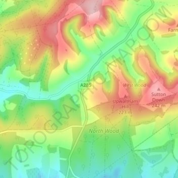
Nombre: Mapa topográfico Upwaltham, altitud, relieve.
Lugar: Upwaltham, Chichester, West Sussex, England, United Kingdom (50.88800 -0.67891 50.92894 -0.64779)
Altitud media: 152 m
Altitud mínima: 75 m
Altitud máxima: 254 m
Haz una donación
Otros mapas topográficos
Haga clic en un mapa para ver su topografía, su altitud y su relieve.
Haz una donación
Haz una donación
Haz una donación
Haz una donación
Haz una donación
Haz una donación
Haz una donación
Haz una donación
Haz una donación
Haz una donación
Haz una donación
Blackdown
United Kingdom > England > West Sussex > Chichester
Blackdown, or Black Down, summit elevation 279.7 metres (918 ft) AMSL, is the highest point in both the historic county of Sussex and the South Downs National Park. It is one of the highest points in the south east of England, exceeded by Walbury Hill, Leith Hill and Pilot Hill. Blackdown is protected as part…
Altitud media: 165 m