
Haz una donación
Mapa topográfico Storrington
Haga clic en el mapa para ver la altitud.
Haz una donación
Acerca de este mapa
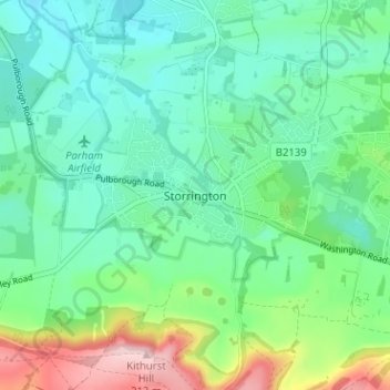
Nombre: Mapa topográfico Storrington, altitud, relieve.
Altitud media: 65 m
Altitud mínima: -3 m
Altitud máxima: 231 m
Haz una donación
Otros mapas topográficos
Haga clic en un mapa para ver su topografía, su altitud y su relieve.
Crawley
United Kingdom > England > West Sussex
Crawley lies within the Sussex Weald, an area of highly variable terrain so that many microclimates of frost hollows, sun traps and windswept hilltops will be encountered over a short distance. During calm, clear periods of weather this allows for some interesting temperature variations, although most of the…
Altitud media: 80 m
Haz una donación
South Downs National Park
United Kingdom > England > West Sussex
The South Downs National Park's chalk downland is a feature that sets it apart from other national parks in Britain. However, almost a quarter (23%) of the national park consists of a quite different and strongly contrasting physiographic region, the western Weald, whose densely wooded hills and vales are…
Altitud media: 54 m
Haz una donación
Haz una donación
Haz una donación
Selsey
United Kingdom > England > West Sussex > Chichester
A study published by Princeton University and McGill University, in 2020, concluded that the Manhood Peninsula is at particularly high risk of flooding as its topography is less than 5 metres (16 ft) above the current mean sea level and that by 2100 Selsey will be subject to permanent inundation.
Altitud media: 1 m
West Wittering
United Kingdom > England > West Sussex > Chichester > West Wittering
Altitud media: 2 m
Haz una donación
Washington Common
United Kingdom > England > West Sussex > Storrington > Washington
Altitud media: 61 m
Haz una donación
Haz una donación
Harting
United Kingdom > England > West Sussex > Chichester > South Harting
Because of its elevation Beacon Hill, just to the east of Harting Down, hosted a station in the shutter telegraph chain, from 1796 to 1816, which connected the Admiralty in London to its naval ships in Portsmouth and Plymouth. This was replaced in 1822 by a semaphore station which operated on a slightly…
Altitud media: 101 m
Haz una donación
Haz una donación
Haz una donación
Haz una donación
Haz una donación
Haz una donación
Haz una donación
Haz una donación
Haz una donación
Haz una donación
Batchelors Farm Nature Conservation Site
United Kingdom > England > West Sussex > Mid Sussex District > Burgess Hill
Altitud media: 49 m
Haz una donación
Haz una donación
Haz una donación
Haz una donación
Haz una donación
Cock Robin Wood
United Kingdom > England > West Sussex > Mid Sussex > East Grinstead > Saint Hill Green
Altitud media: 103 m
Haz una donación
Haz una donación
Haz una donación