
Mapa topográfico Tours
Mapa interactivo
Haga clic en el mapa para ver la altitud.
Acerca de este mapa
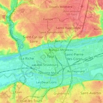
Nombre: Mapa topográfico Tours, altitud, relieve.
Altitud media: 73 m
Altitud mínima: 40 m
Altitud máxima: 116 m
Otros mapas topográficos
Haga clic en un mapa para ver su topografía, su altitud y su relieve.
La Vrillonerie
France > Centre-Val de Loire > Indre-et-Loire > Chambray-lès-Tours
La Vrillonerie, Chambray-lès-Tours, Tours, Indre-et-Loire, Centre-Val de Loire, Metropolitan France, 37170, France
Altitud media: 89 m
Crotelles
France > Centre-Val de Loire > Indre-et-Loire
Crotelles, Loches, Indre-et-Loire, Centre-Val de Loire, Metropolitan France, 37380, France
Altitud media: 130 m
Rigny-Ussé
France > Centre-Val de Loire > Indre-et-Loire
Rigny-Ussé, Arrondissement de Tours, Indre-et-Loire, Centre-Val de Loire, Metropolitan France, 37420, France
Altitud media: 74 m
Chinon
France > Centre-Val de Loire > Indre-et-Loire
Chinon, Indre-et-Loire, Centre-Val de Loire, Metropolitan France, 37500, France
Altitud media: 58 m