
Mapa topográfico Chinon
Mapa interactivo
Haga clic en el mapa para ver la altitud.
Acerca de este mapa
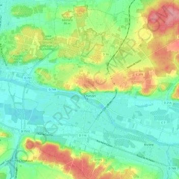
Nombre: Mapa topográfico Chinon, altitud, relieve.
Altitud media: 58 m
Altitud mínima: 24 m
Altitud máxima: 124 m
Topography has played a major role: the formerly fortified town was developed at the foot of the castle on the rocky outcrop, protecting the northern side, with the Vienne River in the south. Apart from the natural defensive protection on both sides, this fact makes a long narrow urban space, with the main streets running parallel to the river.
Otros mapas topográficos
Haga clic en un mapa para ver su topografía, su altitud y su relieve.
La Vrillonerie
France > Centre-Val de Loire > Indre-et-Loire > Chambray-lès-Tours
La Vrillonerie, Chambray-lès-Tours, Tours, Indre-et-Loire, Centre-Val de Loire, Metropolitan France, 37170, France
Altitud media: 89 m
Crotelles
France > Centre-Val de Loire > Indre-et-Loire
Crotelles, Loches, Indre-et-Loire, Centre-Val de Loire, Metropolitan France, 37380, France
Altitud media: 130 m
Tours
France > Centre-Val de Loire > Indre-et-Loire
Tours, Arrondissement de Tours, Indre-et-Loire, Centre-Val de Loire, Metropolitan France, France
Altitud media: 73 m
Rigny-Ussé
France > Centre-Val de Loire > Indre-et-Loire
Rigny-Ussé, Arrondissement de Tours, Indre-et-Loire, Centre-Val de Loire, Metropolitan France, 37420, France
Altitud media: 74 m