
Haz una donación
Mapa topográfico Davie Lake
Haga clic en el mapa para ver la altitud.
Haz una donación
Acerca de este mapa
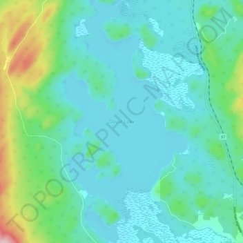
Nombre: Mapa topográfico Davie Lake, altitud, relieve.
Altitud media: 718 m
Altitud mínima: 675 m
Altitud máxima: 904 m
Haz una donación
Otros mapas topográficos
Haga clic en un mapa para ver su topografía, su altitud y su relieve.
Crooked River
Canada > British Columbia > Regional District of Fraser-Fort George > Area G (Crooked River/Parsnip)
Altitud media: 749 m
Carp Lake
Canada > British Columbia > Regional District of Fraser-Fort George > Area G (Crooked River/Parsnip)
Altitud media: 865 m
Salmon Lake
Canada > British Columbia > Regional District of Fraser-Fort George > Area G (Crooked River/Parsnip)
Altitud media: 909 m
Bear Lake
Canada > British Columbia > Regional District of Fraser-Fort George > Area G (Crooked River/Parsnip)
Altitud media: 726 m
Haz una donación
Mugaha Marsh
Canada > British Columbia > Regional District of Fraser-Fort George > Area G (Crooked River/Parsnip)
Altitud media: 681 m
McLeod Lake
Canada > British Columbia > Regional District of Fraser-Fort George > Area G (Crooked River/Parsnip)
A point in the marshes on its southern shore of nearby Summit Lake marks the low point of the divide between the drainages of the Fraser and Peace Rivers, As such it is significant as the prominence col between all points south in the Rockies and beyond and their "parent" summits in northern BC and Alaska.…
Altitud media: 701 m
Coyote Lake
Canada > British Columbia > Regional District of Fraser-Fort George > Area G (Crooked River/Parsnip)
Altitud media: 849 m