
Haz una donación
Mapa topográfico Bear Lake
Haga clic en el mapa para ver la altitud.
Haz una donación
Acerca de este mapa
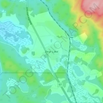
Nombre: Mapa topográfico Bear Lake, altitud, relieve.
Altitud media: 726 m
Altitud mínima: 684 m
Altitud máxima: 872 m
Haz una donación
Otros mapas topográficos
Haga clic en un mapa para ver su topografía, su altitud y su relieve.
Crooked River
Canada > British Columbia > Regional District of Fraser-Fort George > Area G (Crooked River/Parsnip)
Altitud media: 749 m
Carp Lake
Canada > British Columbia > Regional District of Fraser-Fort George > Area G (Crooked River/Parsnip)
Altitud media: 865 m
Salmon Lake
Canada > British Columbia > Regional District of Fraser-Fort George > Area G (Crooked River/Parsnip)
Altitud media: 909 m
Summit Lake
Canada > British Columbia > Regional District of Fraser-Fort George > Area G (Crooked River/Parsnip) > Summit Lake
Summit Lake, elevation 710 m (2329 ft), is a lake in the Central Interior of British Columbia, Canada, located to the north of the city of Prince George. It is the namesake of the community of the same name, which lies alongside the John Hart Highway to the south of the community of McLeod Lake (Fort McLeod).…
Altitud media: 729 m
Haz una donación
Davie Lake
Canada > British Columbia > Regional District of Fraser-Fort George > Area G (Crooked River/Parsnip)
Altitud media: 718 m
Mugaha Marsh
Canada > British Columbia > Regional District of Fraser-Fort George > Area G (Crooked River/Parsnip)
Altitud media: 681 m
Tacheeda Lakes
Canada > British Columbia > Regional District of Fraser-Fort George > Area G (Crooked River/Parsnip)
Altitud media: 875 m
Coyote Lake
Canada > British Columbia > Regional District of Fraser-Fort George > Area G (Crooked River/Parsnip)
Altitud media: 849 m
Haz una donación