
Haz una donación
Mapa topográfico Dromore
Haga clic en el mapa para ver la altitud.
Haz una donación
Acerca de este mapa
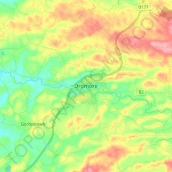
Nombre: Mapa topográfico Dromore, altitud, relieve.
Altitud media: 106 m
Altitud mínima: 56 m
Altitud máxima: 172 m
Haz una donación
Otros mapas topográficos
Haga clic en un mapa para ver su topografía, su altitud y su relieve.
Haz una donación
Haz una donación
Haz una donación
Haz una donación
Ballycullen
United Kingdom > Northern Ireland > County Down > Newtownards > Ballycullen
Altitud media: 49 m
Haz una donación
Haz una donación
Blaris (Castlereagh Upper portion)
United Kingdom > Northern Ireland > County Down > Hillhall
Altitud media: 65 m
Scrabo Tower
United Kingdom > Northern Ireland > County Down > Newtownards
The tower's style is called Scottish Baronial by most recent authors.: "... mysteriously designed in the Scottish baronial style ..." The article in the Illustrated London News of 1857 says "... in the style of a Scottish chateau ...", whereas the article in the Dublin Builder of 1865 calls it "Scotch…
Altitud media: 39 m
Haz una donación
Mourne Esplanade Amentity Area
United Kingdom > Northern Ireland > County Down > Kilkeel
Altitud media: 14 m
Haz una donación