
Haz una donación
Mapa topográfico Newry
Haga clic en el mapa para ver la altitud.
Haz una donación
Acerca de este mapa
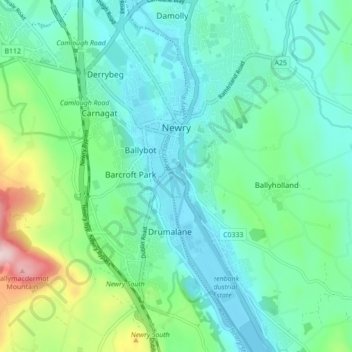
Nombre: Mapa topográfico Newry, altitud, relieve.
Lugar: Newry, County Down, Northern Ireland, United Kingdom (54.14495 -6.36011 54.19597 -6.30507)
Altitud media: 73 m
Altitud mínima: -3 m
Altitud máxima: 326 m
Haz una donación
Otros mapas topográficos
Haga clic en un mapa para ver su topografía, su altitud y su relieve.
Haz una donación
Haz una donación
Haz una donación
Haz una donación
Haz una donación
Haz una donación
Haz una donación
Haz una donación
Haz una donación
Haz una donación
Haz una donación
Haz una donación
Scrabo Tower
United Kingdom > Northern Ireland > County Down > Newtownards
The tower's style is called Scottish Baronial by most recent authors.: "... mysteriously designed in the Scottish baronial style ..." The article in the Illustrated London News of 1857 says "... in the style of a Scottish chateau ...", whereas the article in the Dublin Builder of 1865 calls it "Scotch…
Altitud media: 39 m
Haz una donación
Haz una donación
Haz una donación
Mourne Esplanade Amentity Area
United Kingdom > Northern Ireland > County Down > Kilkeel
Altitud media: 14 m
Haz una donación
Haz una donación