
Gracias por apoyar a este sitio ❤️
Haz una donación
Haz una donación
Mapa topográfico Bathgate
Haga clic en el mapa para ver la altitud.
Gracias por apoyar a este sitio ❤️
Haz una donación
Haz una donación
Bathgate
In the 1846 book A Topographical Dictionary of Scotland, Samuel Lewis writes.
Gracias por apoyar a este sitio ❤️
Haz una donación
Haz una donación
Acerca de este mapa
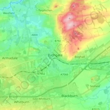
Nombre: Mapa topográfico Bathgate, altitud, relieve.
Lugar: Bathgate, West Lothian, Scotland, EH48 1PA, United Kingdom (55.86092 -3.68148 55.94092 -3.60148)
Altitud media: 167 m
Altitud mínima: 97 m
Altitud máxima: 311 m
Gracias por apoyar a este sitio ❤️
Haz una donación
Haz una donación
Otros mapas topográficos
Haga clic en un mapa para ver su topografía, su altitud y su relieve.
Linlithgow Palace and High Street Conservation Area
United Kingdom > Scotland > West Lothian > Linlithgow
Altitud media: 78 m
Gracias por apoyar a este sitio ❤️
Haz una donación
Haz una donación