
Haz una donación
Mapa topográfico Deans
Haga clic en el mapa para ver la altitud.
Haz una donación
Acerca de este mapa
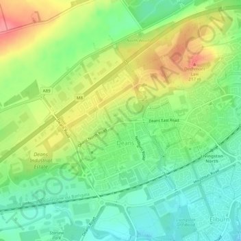
Nombre: Mapa topográfico Deans, altitud, relieve.
Lugar: Deans, West Lothian, Scotland, United Kingdom (55.89659 -3.57410 55.91306 -3.54186)
Altitud media: 164 m
Altitud mínima: 128 m
Altitud máxima: 215 m
Haz una donación
Otros mapas topográficos
Haga clic en un mapa para ver su topografía, su altitud y su relieve.
Bathgate
United Kingdom > Scotland > West Lothian
In the 1846 book A Topographical Dictionary of Scotland, Samuel Lewis writes.
Altitud media: 167 m
Haz una donación
Haz una donación
Haz una donación
Haz una donación
Haz una donación
Haz una donación
Armadale
United Kingdom > Scotland > West Lothian
Aside from the presence of the old castle, Armadale was little more than a rural farm community for most of its history, as part of a larger rural estate named Barbauchlaw (a corruption of 'Boar Baughlee'). However, this situation changed with the coming of the new turnpike road between Edinburgh and Glasgow…
Altitud media: 166 m
Haz una donación
Haz una donación
Bathgate
United Kingdom > Scotland > West Lothian
In the 1846 book A Topographical Dictionary of Scotland, Samuel Lewis writes.
Altitud media: 167 m
Haz una donación