
Mapa topográfico Hillhall
Mapa interactivo
Haga clic en el mapa para ver la altitud.
Acerca de este mapa
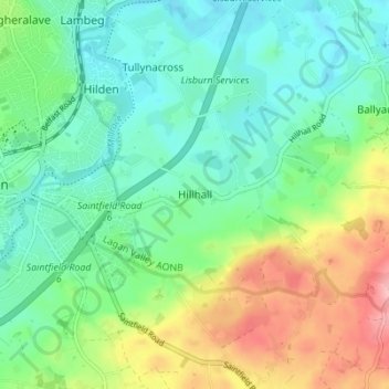
Nombre: Mapa topográfico Hillhall, altitud, relieve.
Altitud media: 61 m
Altitud mínima: 17 m
Altitud máxima: 158 m
Otros mapas topográficos
Haga clic en un mapa para ver su topografía, su altitud y su relieve.
Benraw
United Kingdom > Northern Ireland > County Down
Benraw, County Down, Ulster, Northern Ireland, United Kingdom
Altitud media: 182 m
Newry
United Kingdom > Northern Ireland > County Down
Newry, County Down, Northern Ireland, United Kingdom
Altitud media: 73 m
Banbridge
United Kingdom > Northern Ireland > County Down
Banbridge, County Down, Northern Ireland, BT32 3DB, United Kingdom
Altitud media: 90 m
Carryduff
United Kingdom > Northern Ireland > County Down > Carryduff
Carryduff, County Down, Northern Ireland, BT8 8DN, United Kingdom
Altitud media: 110 m
Newry
United Kingdom > Northern Ireland > County Down > Newry
Newry, County Down, Northern Ireland, BT34 1DG, United Kingdom
Altitud media: 129 m
Slieve Donard
United Kingdom > Northern Ireland > County Down
Slieve Donard, County Down, Northern Ireland, BT33 0HD, United Kingdom
Altitud media: 505 m