
Mapa topográfico Lake Tekapo
Mapa interactivo
Haga clic en el mapa para ver la altitud.
Acerca de este mapa
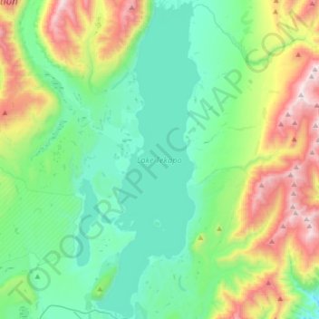
Nombre: Mapa topográfico Lake Tekapo, altitud, relieve.
Lugar: Lake Tekapo, Mackenzie District, Canterbury, New Zealand (-44.00704 170.46177 -43.77987 170.56512)
Altitud media: 1.025 m
Altitud mínima: 623 m
Altitud máxima: 2.136 m
Lake Tekapo (Māori: Takapō) is the second-largest of three roughly parallel lakes running north–south along the northern edge of the Mackenzie Basin in the South Island of New Zealand (the others are Lake Pukaki and Lake Ōhau). It covers an area of 83 square kilometres (32 sq mi) and is at an altitude of 710 metres (2,330 ft) above sea level.
Otros mapas topográficos
Haga clic en un mapa para ver su topografía, su altitud y su relieve.
Mount Blackburn
New Zealand > Canterbury > Mackenzie District
Mount Blackburn, Mackenzie District, Canterbury, New Zealand
Altitud media: 1.634 m
Twizel
New Zealand > Canterbury > Mackenzie District
Twizel, Mackenzie District, Canterbury, 7901, New Zealand
Altitud media: 472 m
Burkes Pass
New Zealand > Canterbury > Mackenzie District > Burkes Pass
Burkes Pass, Mackenzie District, Canterbury, New Zealand
Altitud media: 622 m
Mount Cook
New Zealand > Canterbury > Mackenzie District
Mount Cook, Mackenzie District, Canterbury, New Zealand
Altitud media: 2.920 m
Lake Benmore
New Zealand > Canterbury > Mackenzie District
Lake Benmore, Mackenzie District, Canterbury, New Zealand
Altitud media: 745 m
Fairlie
New Zealand > Canterbury > Mackenzie District
Fairlie, Mackenzie District, Canterbury, 7925, New Zealand
Altitud media: 317 m
Tasman Lake
New Zealand > Canterbury > Mackenzie District
Tasman Lake, Mackenzie District, Canterbury, New Zealand
Altitud media: 1.060 m
Lake Pukaki
New Zealand > Canterbury > Mackenzie District
Lake Pukaki, Mackenzie District, Canterbury, New Zealand
Altitud media: 886 m