
Mapa topográfico Mount Cook
Mapa interactivo
Haga clic en el mapa para ver la altitud.
Acerca de este mapa
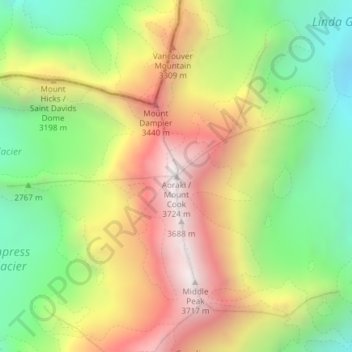
Nombre: Mapa topográfico Mount Cook, altitud, relieve.
Lugar: Mount Cook, Mackenzie District, Canterbury, New Zealand (-43.59505 170.14212 -43.59495 170.14222)
Altitud media: 2.920 m
Altitud mínima: 2.235 m
Altitud máxima: 3.709 m
Temperatures at the mountain's base in the Hooker Valley around 800 metres (2,600 feet) range from −13 °C (9 °F) to 32 °C (90 °F), and generally fall just over 1 °C for every 200 metres of altitude.
Otros mapas topográficos
Haga clic en un mapa para ver su topografía, su altitud y su relieve.
Mount Blackburn
New Zealand > Canterbury > Mackenzie District
Mount Blackburn, Mackenzie District, Canterbury, New Zealand
Altitud media: 1.634 m
Twizel
New Zealand > Canterbury > Mackenzie District
Twizel, Mackenzie District, Canterbury, 7901, New Zealand
Altitud media: 472 m
Burkes Pass
New Zealand > Canterbury > Mackenzie District > Burkes Pass
Burkes Pass, Mackenzie District, Canterbury, New Zealand
Altitud media: 622 m
Lake Benmore
New Zealand > Canterbury > Mackenzie District
Lake Benmore, Mackenzie District, Canterbury, New Zealand
Altitud media: 745 m
Fairlie
New Zealand > Canterbury > Mackenzie District
Fairlie, Mackenzie District, Canterbury, 7925, New Zealand
Altitud media: 317 m
Lake Tekapo
New Zealand > Canterbury > Mackenzie District
Lake Tekapo, Mackenzie District, Canterbury, New Zealand
Altitud media: 1.025 m
Lake Pukaki
New Zealand > Canterbury > Mackenzie District
Lake Pukaki, Mackenzie District, Canterbury, New Zealand
Altitud media: 886 m
Tasman Lake
New Zealand > Canterbury > Mackenzie District
Tasman Lake, Mackenzie District, Canterbury, New Zealand
Altitud media: 1.060 m