
Haz una donación
Mapa topográfico United Kingdom
Haga clic en el mapa para ver la altitud.
Haz una donación
United Kingdom
Scotland accounts for just under a third (32 per cent) of the total area of the UK, covering 78,772 square kilometres (30,410 sq mi). This includes nearly eight hundred islands, predominantly west and north of the mainland; notably the Hebrides, Orkney Islands and Shetland Islands. Scotland is the most mountainous country in the UK and its topography is distinguished by the Highland Boundary Fault – a geological rock fracture – which traverses Scotland from Arran in the west to Stonehaven in the east. The fault separates two distinctively different regions; namely the Highlands to the north and west and the Lowlands to the south and east. The more rugged Highland region contains the majority of Scotland's mountainous land, including Ben Nevis which at 1,345 metres (4,413 ft) is the highest point in the British Isles. Lowland areas – especially the narrow waist of land between the Firth of Clyde and the Firth of Forth known as the Central Belt – are flatter and home to most of the population including Glasgow, Scotland's largest city, and Edinburgh, its capital and political centre, although upland and mountainous terrain lies within the Southern Uplands.
Haz una donación
Acerca de este mapa
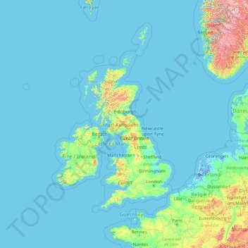
Nombre: Mapa topográfico United Kingdom, altitud, relieve.
Lugar: United Kingdom (47.20235 -10.77658 62.20235 4.22342)
Altitud media: 79 m
Altitud mínima: -6 m
Altitud máxima: 2.206 m
Haz una donación
Otros mapas topográficos
Haga clic en un mapa para ver su topografía, su altitud y su relieve.
England
England's topography is characterized by a diverse landscape that transitions from low-lying plains to rugged uplands. In the north and west, the terrain is dominated by mountain ranges such as the Pennines, often referred to as the "backbone of England," and the Lake District, which includes Scafell Pike, the…
Altitud media: 55 m
Scotland
Scotland's topography is a tapestry of rugged mountains, rolling hills, and expansive coastlines. The Highlands, occupying the northern and western regions, are characterized by towering peaks such as Ben Nevis, the UK's highest at 1,345 meters, and deep glens carved by ancient glaciers. The Grampian…
Altitud media: 36 m
Haz una donación
Sheffield
Sheffield nestles on the eastern foothills of the Pennines and is sculpted by a dramatic hill-and-valley system formed where five rivers — the Don, Sheaf, Rivelin, Loxley and Porter — converge, producing steep-sided valleys and gritstone ridgelines with much of the urban area built directly onto hillsides…
Altitud media: 168 m
Wales
Wales is predominantly mountainous, with its terrain shaped by ancient geological processes and glaciation. In the north, Snowdonia (Eryri) boasts the country's highest peaks, including Snowdon (Yr Wyddfa) at 1,085 meters (3,560 feet). Central Wales is characterized by the Cambrian Mountains, featuring…
Altitud media: 99 m
Kent
Kent was also the location of the largest number of art schools in the country during the nineteenth century, estimated by the art historian David Haste, to approach two hundred. This is believed to be the result of Kent being a front line county during the Napoleonic Wars. At this time, before the invention…
Altitud media: 37 m
Haz una donación
Bath
United Kingdom > England > Bath and North East Somerset
Bath is in the Avon Valley and is surrounded by limestone hills as it is near the southern edge of the Cotswolds, a designated Area of Outstanding Natural Beauty, and the limestone Mendip Hills rise around 7 miles (11 km) south of the city. The hills that surround and make up the city have a maximum altitude…
Altitud media: 100 m
Birmingham
Birmingham is a snowy city relative to other large UK conurbations, due to its inland location and comparatively high elevation. Between 1961 and 1990 Birmingham Airport averaged 13.0 days of snow lying annually, compared to 5.33 at London Heathrow. Snow showers often pass through the city via the Cheshire gap…
Altitud media: 138 m
North East England
North East England has a Marine west coast climate (generally found along the west coast of middle latitude continents) with narrower temperature ranges than the south of England and sufficient precipitation in all months. Summers and winters are mild rather than extremely hot or cold, due to the strong…
Altitud media: 165 m
Haz una donación
Haz una donación
England
England's topography is characterized by a diverse landscape that transitions from low-lying plains to rugged uplands. In the north and west, the terrain is dominated by mountain ranges such as the Pennines, often referred to as the "backbone of England," and the Lake District, which includes Scafell Pike, the…
Altitud media: 55 m
Great Britain
Great Britain's topography is characterized by a diverse landscape shaped by its geological history. The island predominantly features lowland terrain in the east and south, with rolling countryside and plains, while the western and northern regions are marked by hills and mountains. Notable upland areas…
Altitud media: 52 m
Haz una donación
Skye
United Kingdom > Scotland > Highland
Beyond Loch Snizort to the west of Trotternish is the Waternish peninsula, which ends in Ardmore Point's double rock arch. Duirinish peninsula is separated from Waternish by Loch Dunvegan, which contains the island of Isay. It is ringed by sea cliffs that reach 296 metres (971 feet) on the west at Waterstein…
Altitud media: 63 m
East of England
The East of England region has the lowest elevation range in the UK. Twenty percent of the region is below mean sea level, most of this in North Cambridgeshire, Norfolk and on the Essex Coast. Most of the remaining area is of low elevation, with extensive glacial deposits. The Fens, a large area of reclaimed…
Altitud media: 39 m
Haz una donación
Exeter
United Kingdom > England > Devon
The city of Exeter was established on the eastern bank of the River Exe on a ridge of land backed by a steep hill. It is at this point that the Exe, having just been joined by the River Creedy, opens onto a wide flood plain and estuary which results in quite common flooding. Historically this was the lowest…
Altitud media: 56 m
England
England's topography is characterized by a diverse landscape that transitions from low-lying plains to rugged uplands. In the north and west, the terrain is dominated by mountain ranges such as the Pennines, often referred to as the "backbone of England," and the Lake District, which includes Scafell Pike, the…
Altitud media: 55 m
Haz una donación
Haz una donación
South East England
Near Weybridge are the UK headquarters of Sony with SSP Group (situated in Byfleet) and Procter & Gamble (next door to each other on The Heights Business Park near the former Brooklands racing circuit) with Kia Motors UK and Petroleum Geo-Services UK, and Gallaher Group (cigarettes) is to the north, next to…
Altitud media: 69 m
City of Edinburgh
Edinburgh has been popularly called the Athens of the North since the early 19th century. References to Athens, such as Athens of Britain and Modern Athens, had been made as early as the 1760s. The similarities were seen to be topographical but also intellectual. Edinburgh's Castle Rock reminded returning…
Altitud media: 118 m
Haz una donación
Cambridge
United Kingdom > England > Cambridge
The city, like most of the UK, has a maritime climate highly influenced by the Gulf Stream. Located in the driest region of Britain, Cambridge's rainfall averages around 570 mm (22.44 in) per year, around half the national average, with some years occasionally falling into the semi-arid (under 500 mm (19.69…
Altitud media: 18 m
Derbyshire
Due to its central location in England and altitude range from 27 metres in the south to 636 metres in the north, Derbyshire contains many species at the edge of their UK distribution ranges. Some species with a predominantly northern British distribution are at the southern limit of their range, whilst others…
Altitud media: 144 m
Dartmoor National Park
United Kingdom > England > Devon
Rainfall tends to be associated with Atlantic depressions or with convection. In summer, convection caused by solar surface heating sometimes forms shower clouds and a large proportion of rainfall falls from showers and thunderstorms at this time of year. The wettest months are November and December and on the…
Altitud media: 239 m
Haz una donación
Haz una donación
Lake District National Park
The Lake District is a roughly circular upland massif, deeply dissected by a broadly radial pattern of major valleys which are largely the result of repeated glaciations over the last 2 million years. The apparent radial pattern is not from a central dome, but from an axial watershed extending from St Bees…
Altitud media: 206 m
London
London's topography is characterized by a gently rolling terrain shaped by the River Thames and its tributaries. The city lies within the London Basin, a natural depression bordered by higher grounds such as the North Downs to the south and the Chiltern Hills to the northwest. The Thames flows west to east,…
Altitud media: 66 m
Haz una donación
Yorkshire
In Yorkshire there is a very close relationship between the major topographical areas and the geological period in which they were formed. The Pennine chain of hills in the west is of Carboniferous origin. The central vale is Permo-Triassic. The North York Moors in the north-east of the county are Jurassic in…
Altitud media: 130 m
Great Britain
Great Britain's topography is characterized by a diverse landscape shaped by its geological history. The island predominantly features lowland terrain in the east and south, with rolling countryside and plains, while the western and northern regions are marked by hills and mountains. Notable upland areas…
Altitud media: 52 m
Haz una donación
Haz una donación
Haz una donación
Wales
Wales is predominantly mountainous, with its terrain shaped by ancient geological processes and glaciation. In the north, Snowdonia (Eryri) boasts the country's highest peaks, including Snowdon (Yr Wyddfa) at 1,085 meters (3,560 feet). Central Wales is characterized by the Cambrian Mountains, featuring…
Altitud media: 99 m
South West England
Inland areas of low altitude experience the least amount of precipitation. They experience the highest summer maxima temperatures, but winter minima are colder than the coast. Snowfalls are more frequent in comparison to the coast, but less so in comparison to higher ground. It experiences the lowest wind…
Altitud media: 68 m
Haz una donación
Yorkshire and the Humber
In the Yorkshire and the Humber region, there is a very close relationship between the major topographical areas and the underlying geology. The Pennine chain of hills in the west is of Carboniferous origin. The central vale is Permo-Triassic. The North York Moors in the north-east of the region are Jurassic…
Altitud media: 120 m
Haz una donación
Suffolk
The west of the county lies on more resistant Cretaceous chalk. This chalk is responsible for a sweeping tract of largely downland landscapes that stretches from Dorset in the south west to Dover in the south east and north through East Anglia to the Yorkshire Wolds. The chalk is less easily eroded so forms…
Altitud media: 35 m
Pembrokeshire
There is little evidence of Roman occupation in what is now Pembrokeshire. Ptolemy's Geography, written c. 150, mentioned some coastal places, two of which have been identified as the River Teifi and what is now St Davids Head, but most Roman writers did not mention the area; there may have been a Roman…
Altitud media: 43 m
City of Westminster
The area was historically part of the county of Middlesex. Whilst an important centre of royal authority from Saxon times, Westminster was not formally incorporated as a borough for local government purposes until 1900. However, it was declared a city in 1540 on the elevation of Westminster Abbey to being a…
Altitud media: 23 m
Haz una donación
Farnham
United Kingdom > England > Surrey > Waverley
Farnham lies in the valley of the North Branch of the River Wey, which rises near Alton, merges with the South Branch at Tilford, and joins the River Thames at Weybridge. The mainly east-west alignment of the ridges and valleys has influenced the development of road and rail communications. The most prominent…
Altitud media: 100 m
Lincoln
United Kingdom > England > Lincolnshire
Lincoln lies 157 mi (253 km) north of London, at an altitude of 67 ft (20.4 m) by the River Witham up to 246 ft (75.0 m) on Castle Hill. It fills a gap in the Lincoln Cliff escarpment, which runs north and south through central Lincolnshire, with altitudes up to 200 feet (61 metres). The city lies on the River…
Altitud media: 29 m
Haz una donación
Connaught Water
United Kingdom > England > Essex > Epping Forest > Sewardstonebury
Altitud media: 57 m
Stoke-on-Trent
In 1919, the borough proposed to expand further and annex the neighbouring borough of Newcastle-under-Lyme and the Wolstanton United Urban District, both to the west of Stoke. This never took place, due to strong objections from Newcastle Corporation. A further attempt was made in 1930, with the promotion of…
Altitud media: 168 m
Haz una donación
Windermere
United Kingdom > England > Cumbria > South Lakeland > Bowness-on-Windermere
There is debate as to whether the stretch of water between Newby Bridge and Lakeside at the southern end of the lake should be considered part of Windermere, or a navigable stretch of the River Leven. This affects the stated length of the lake, which is 11.23 miles (18.07 km) long if measured from the bridge…
Altitud media: 132 m
Brecon Beacons National Park
United Kingdom > Wales > Powys
Brecon Beacons National Park, officially named Bannau Brycheiniog National Park (Welsh pronunciation), is a national park in Wales. It is named after the Brecon Beacons (Welsh: Bannau Brycheiniog), the mountain range at its centre. The national park includes the highest mountain in South Wales, Pen y Fan,…
Altitud media: 270 m
Haz una donación
Haz una donación
Chilterns National Landscape
United Kingdom > England > Buckinghamshire
The highest point is at 267 m (876 ft.) above sea level at Haddington Hill near Wendover in Buckinghamshire; a stone monument marks the summit. The nearby Ivinghoe Beacon is a more prominent hill, although its altitude is only 249 m (817 ft.). It is the starting point of the Icknield Way Path and the Ridgeway…
Altitud media: 102 m
Haz una donación
Haz una donación
Haz una donación