
Haz una donación
Mapa topográfico Pembrokeshire
Haga clic en el mapa para ver la altitud.
Haz una donación
Pembrokeshire
There is little evidence of Roman occupation in what is now Pembrokeshire. Ptolemy's Geography, written c. 150, mentioned some coastal places, two of which have been identified as the River Teifi and what is now St Davids Head, but most Roman writers did not mention the area; there may have been a Roman settlement near St Davids and a road from Bath, but this comes from a 14th-century writer. Any evidence for villas or Roman building materials reported by mediaeval or later writers has not been verified, though some remains near Dale were tentatively identified as Roman in character by topographer Richard Fenton in his Historical Tour of 1810. Fenton stated that he had "...reason to be of opinion that they had not colonized Pembrokeshire till near the decline of their empire in Britain".
Haz una donación
Acerca de este mapa
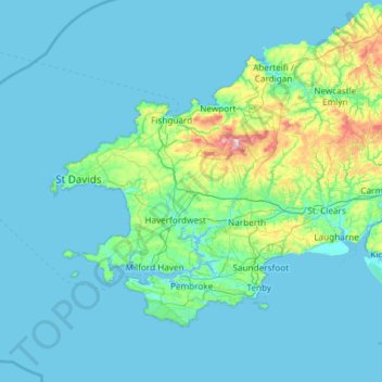
Nombre: Mapa topográfico Pembrokeshire, altitud, relieve.
Lugar: Pembrokeshire, Wales, United Kingdom (51.59592 -5.67030 52.11804 -4.48559)
Altitud media: 43 m
Altitud mínima: 0 m
Altitud máxima: 521 m
Haz una donación
Otros mapas topográficos
Haga clic en un mapa para ver su topografía, su altitud y su relieve.
Haz una donación
Haz una donación
Haz una donación
Snowdon
United Kingdom > Wales > Gwynedd
Snowdon (/ˈsnoʊdən/) or Yr Wyddfa (pronounced [ər ˈʊɨ̞̯ðva] (listen)), is the highest mountain in Wales, at an elevation of 1,085 metres (3,560 ft) above sea level, and the highest point in the British Isles outside the Scottish Highlands. It is located in Snowdonia National Park (Parc Cenedlaethol…
Altitud media: 692 m
Haz una donación
Swansea
United Kingdom > Wales > Swansea
Much of Swansea is hilly with the main area of upland being located in the council ward of Mawr. Areas up to 185 metres (607 ft) in elevation range across the central section: Kilvey Hill, Townhill and Llwynmawr separate the centre of Swansea from its northern suburbs. Cefn Bryn, a ridge of high land, is the…
Altitud media: 73 m
Haz una donación
Haz una donación
Haz una donación
Haz una donación
Haz una donación
River Severn
United Kingdom > Wales > Powys > Welshpool
The River Severn (Welsh: Afon Hafren, pronounced [ˈavɔn ˈhavrɛn]), at 220 miles (354 km) long, is the longest river in Great Britain. It is also the river with the most voluminous flow of water by far in all of England and Wales, with an average flow rate of 107 m3/s (3,800 cu ft/s) at Apperley,…
Altitud media: 92 m
Haz una donación
Haz una donación
Haz una donación
Haz una donación
Aberystwyth
United Kingdom > Wales > Ceredigion
Aberystwyth experiences an oceanic climate (Köppen climate classification Cfb) similar to almost all of the United Kingdom. This is particularly pronounced due to its west coast location facing the Irish Sea. Air undergoes little land moderation and so temperatures closely reflect the sea temperature when…
Altitud media: 39 m
Haz una donación
Haz una donación
Haz una donación
Haz una donación
Haz una donación
Haz una donación
Haz una donación
Haz una donación
Haz una donación
Haz una donación
Parc Tan-y-Bwlch
United Kingdom > Wales > Gwynedd > Mynydd Llandygái > Pen Y Bwlch
Altitud media: 293 m
Haz una donación
Haz una donación