
Haz una donación
Mapa topográfico Swansea
Haga clic en el mapa para ver la altitud.
Haz una donación
Swansea
Much of Swansea is hilly with the main area of upland being located in the council ward of Mawr. Areas up to 185 metres (607 ft) in elevation range across the central section: Kilvey Hill, Townhill and Llwynmawr separate the centre of Swansea from its northern suburbs. Cefn Bryn, a ridge of high land, is the backbone of the Gower Peninsula. Rhossili Down, Hardings Down and Llanmadoc Hill are up to 193 metres (633 ft) high. The highest point is located Penlle'r Castell at 374 metres (1,227 ft) on the northern border with Carmarthenshire.
Haz una donación
Acerca de este mapa
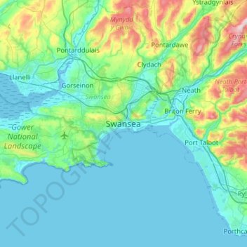
Nombre: Mapa topográfico Swansea, altitud, relieve.
Lugar: Swansea, Wales, SA1 3BP, United Kingdom (51.45960 -4.10592 51.77960 -3.78592)
Altitud media: 73 m
Altitud mínima: -2 m
Altitud máxima: 464 m
Haz una donación
Otros mapas topográficos
Haga clic en un mapa para ver su topografía, su altitud y su relieve.
Haz una donación
Haz una donación
Haz una donación
Haz una donación
Haz una donación