
Haz una donación
Mapa topográfico Lone Butte
Haga clic en el mapa para ver la altitud.
Haz una donación
Lone Butte
The northward advance of the Pacific Great Eastern Railway (PGE) rail head passed through Lone Butte in late April 1919. This construction camp had a large kitchen employing 25 cooks, of whom two received the Distinguished Conduct Medal and three the Military Medal during World War I. At an elevation of about 1,140 metres (3,740 ft), the former station was the highest on the line.
Haz una donación
Acerca de este mapa
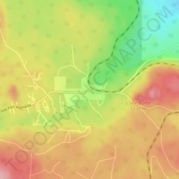
Nombre: Mapa topográfico Lone Butte, altitud, relieve.
Altitud media: 1.159 m
Altitud mínima: 1.084 m
Altitud máxima: 1.225 m
Haz una donación
Otros mapas topográficos
Haga clic en un mapa para ver su topografía, su altitud y su relieve.
Horse Lake
Canada > British Columbia > Cariboo Regional District > Area L (Lone Butte/Interlakes)
Altitud media: 1.097 m
Needa Lake
Canada > British Columbia > Cariboo Regional District > Area L (Lone Butte/Interlakes)
Altitud media: 1.192 m
Sheridan Lake
Canada > British Columbia > Cariboo Regional District > Area L (Lone Butte/Interlakes)
Altitud media: 1.127 m
Interlakes
Canada > British Columbia > Cariboo Regional District > Area L (Lone Butte/Interlakes)
Altitud media: 1.126 m
Haz una donación
Bridge Lake
Canada > British Columbia > Cariboo Regional District > Area L (Lone Butte/Interlakes)
Altitud media: 1.158 m