
Haz una donación
Mapa topográfico Bridge Lake
Haga clic en el mapa para ver la altitud.
Haz una donación
Acerca de este mapa
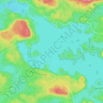
Nombre: Mapa topográfico Bridge Lake, altitud, relieve.
Altitud media: 1.158 m
Altitud mínima: 1.125 m
Altitud máxima: 1.248 m
Haz una donación
Otros mapas topográficos
Haga clic en un mapa para ver su topografía, su altitud y su relieve.
Lone Butte
Canada > British Columbia > Cariboo Regional District > Area L (Lone Butte/Interlakes)
The northward advance of the Pacific Great Eastern Railway (PGE) rail head passed through Lone Butte in late April 1919. This construction camp had a large kitchen employing 25 cooks, of whom two received the Distinguished Conduct Medal and three the Military Medal during World War I. At an elevation of about…
Altitud media: 1.159 m
Deka Lake
Canada > British Columbia > Cariboo Regional District > Area L (Lone Butte/Interlakes)
Altitud media: 1.141 m
Interlakes
Canada > British Columbia > Cariboo Regional District > Area L (Lone Butte/Interlakes)
Altitud media: 1.126 m