
Haz una donación
Mapa topográfico Dundrum
Haga clic en el mapa para ver la altitud.
Haz una donación
Acerca de este mapa
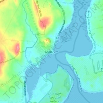
Nombre: Mapa topográfico Dundrum, altitud, relieve.
Altitud media: 18 m
Altitud mínima: -2 m
Altitud máxima: 91 m
Haz una donación
Otros mapas topográficos
Haga clic en un mapa para ver su topografía, su altitud y su relieve.
Haz una donación
Haz una donación
County Antrim
United Kingdom > Northern Ireland
A large portion of Antrim is hilly, especially in the east, where the highest elevations are attained. The range runs north and south, and, following this direction, the highest points are Knocklayd 514 m (1,690 ft), Slieveanorra 508 m (1,670 ft), Trostan 550 m (1,800 ft), Slemish 437 m (1,430 ft), Agnew's…
Altitud media: 70 m
Haz una donación
Haz una donación
Haz una donación
Haz una donación
Haz una donación
Haz una donación
Haz una donación
Haz una donación
Haz una donación
Haz una donación
Haz una donación
Haz una donación
Haz una donación
Haz una donación
Haz una donación
Haz una donación
Haz una donación
Haz una donación
Haz una donación
Haz una donación
Haz una donación
Castlecaufield
United Kingdom > Northern Ireland > County Tyrone > Castlecaulfield
Altitud media: 95 m
Loughgiel Millennium Centre
United Kingdom > Northern Ireland > County Antrim > Loughguile
Altitud media: 155 m
Haz una donación
Drumahoe
United Kingdom > Northern Ireland > County Londonderry > Derry/Londonderry
Altitud media: 46 m
Causeway Coast and Glens District
United Kingdom > Northern Ireland > County Londonderry
Altitud media: 101 m
Haz una donación