
Mapa topográfico Lingshed
Mapa interactivo
Haga clic en el mapa para ver la altitud.
Acerca de este mapa
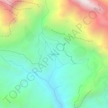
Nombre: Mapa topográfico Lingshed, altitud, relieve.
Lugar: Lingshed, Khalsi tehsil, Leh District, Ladakh, Inde (33.88384 76.80465 33.92384 76.84465)
Altitud media: 4.209 m
Altitud mínima: 3.574 m
Altitud máxima: 5.487 m
Otros mapas topográficos
Haga clic en un mapa para ver su topografía, su altitud y su relieve.
Ursi
Inde > Ladakh > Khalsi tehsil
Ursi, Khalsi tehsil, Leh District, Ladakh, Inde
Altitud media: 3.941 m
Uleytokpo
Inde > Ladakh > Khalsi tehsil
Uleytokpo, Khalsi tehsil, Leh District, Ladakh, Inde
Altitud media: 3.361 m
Khaltse
Inde > Ladakh > Khalsi tehsil
Khaltse, Khalsi tehsil, Leh District, Ladakh, Inde
Altitud media: 3.287 m
Lamayuru
Inde > Ladakh > Khalsi tehsil
Lamayuru, Khalsi tehsil, Leh District, Ladakh, Inde
Altitud media: 3.691 m