
Mapa topográfico Uleytokpo
Mapa interactivo
Haga clic en el mapa para ver la altitud.
Acerca de este mapa
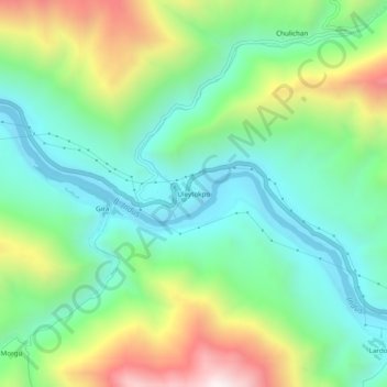
Nombre: Mapa topográfico Uleytokpo, altitud, relieve.
Lugar: Uleytokpo, Khalsi tehsil, Leh District, Ladakh, Inde (34.23349 77.07262 34.27349 77.11262)
Altitud media: 3.361 m
Altitud mínima: 3.020 m
Altitud máxima: 4.074 m
Otros mapas topográficos
Haga clic en un mapa para ver su topografía, su altitud y su relieve.
Ursi
Inde > Ladakh > Khalsi tehsil
Ursi, Khalsi tehsil, Leh District, Ladakh, Inde
Altitud media: 3.941 m
Lingshed
Inde > Ladakh > Khalsi tehsil
Lingshed, Khalsi tehsil, Leh District, Ladakh, Inde
Altitud media: 4.209 m
Khaltse
Inde > Ladakh > Khalsi tehsil
Khaltse, Khalsi tehsil, Leh District, Ladakh, Inde
Altitud media: 3.287 m
Lamayuru
Inde > Ladakh > Khalsi tehsil
Lamayuru, Khalsi tehsil, Leh District, Ladakh, Inde
Altitud media: 3.691 m