
Haz una donación
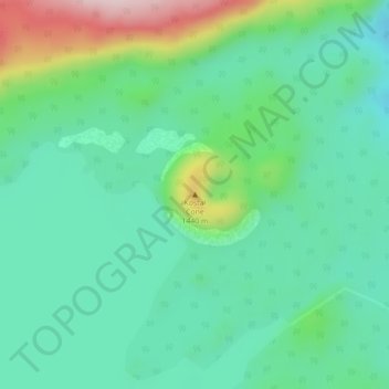
Mapa topográfico Fire Mountain
Haga clic en el mapa para ver la altitud.
Haz una donación
Fire Mountain
Kostal Cone, also called Kostal Volcano and Fire Mountain, is a young cinder cone in Wells Gray Provincial Park in east-central British Columbia, Canada. It rises from the northeast shore of Kostal Lake in the Cariboo Mountains. With an elevation of 1,440 m (4,724 ft), Kostal Cone is one of the lowest volcanoes in the Wells Gray-Clearwater volcanic field.
Haz una donación
Acerca de este mapa
Nombre: Mapa topográfico Fire Mountain, altitud, relieve.
Altitud media: 1.316 m
Altitud mínima: 1.231 m
Altitud máxima: 1.545 m
Haz una donación
Otros mapas topográficos
Haga clic en un mapa para ver su topografía, su altitud y su relieve.
Strait Lake
Canada > British Columbia > Thompson-Nicola Regional District > Area A (Wells Gray Country)
Altitud media: 1.531 m
Murtle Lake
Canada > British Columbia > Thompson-Nicola Regional District > Area A (Wells Gray Country)
Altitud media: 1.470 m