
Haz una donación
Mapa topográfico Murtle Lake
Haga clic en el mapa para ver la altitud.
Haz una donación
Acerca de este mapa
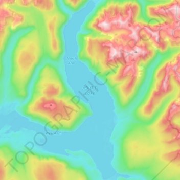
Nombre: Mapa topográfico Murtle Lake, altitud, relieve.
Altitud media: 1.470 m
Altitud mínima: 1.059 m
Altitud máxima: 2.442 m
Haz una donación
Otros mapas topográficos
Haga clic en un mapa para ver su topografía, su altitud y su relieve.
Fire Mountain
Canada > British Columbia > Thompson-Nicola Regional District > Area A (Wells Gray Country)
Kostal Cone, also called Kostal Volcano and Fire Mountain, is a young cinder cone in Wells Gray Provincial Park in east-central British Columbia, Canada. It rises from the northeast shore of Kostal Lake in the Cariboo Mountains. With an elevation of 1,440 m (4,724 ft), Kostal Cone is one of the lowest…
Altitud media: 1.316 m
Dragon Cone
Canada > British Columbia > Thompson-Nicola Regional District > Area A (Wells Gray Country)
Altitud media: 1.703 m
McLeod Hill
Canada > British Columbia > Thompson-Nicola Regional District > Area A (Wells Gray Country)
Altitud media: 1.133 m
Vavenby
Canada > British Columbia > Thompson-Nicola Regional District > Area A (Wells Gray Country)
Altitud media: 642 m
Haz una donación
Strait Lake
Canada > British Columbia > Thompson-Nicola Regional District > Area A (Wells Gray Country)
Altitud media: 1.531 m
Vimy Ridge
Canada > British Columbia > Thompson-Nicola Regional District > Area A (Wells Gray Country)
Altitud media: 1.871 m