
Mapa topográfico Khuzdar
Mapa interactivo
Haga clic en el mapa para ver la altitud.
Acerca de este mapa
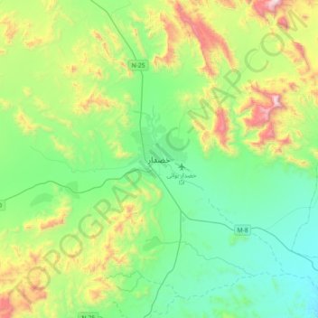
Nombre: Mapa topográfico Khuzdar, altitud, relieve.
Lugar: Khuzdar, Khuzdar District, Balochistan, 89100, Pakistan (27.64001 66.45665 27.96001 66.77665)
Altitud media: 1.417 m
Altitud mínima: 1.033 m
Altitud máxima: 2.438 m
Khuzdar is at the apex of a narrow valley at an elevation of 1,237 metres (4,058 ft). Despite this altitude, Khuzdar like most of Balochistan has an arid climate (Köppen BWh) with very low and erratic rainfall. Unlike most parts of the province, the heaviest average rainfall comes from the Asian monsoon in July and August, though this rainfall tends to be very erratic and in many summers there is no significant rain at all.
Otros mapas topográficos
Haga clic en un mapa para ver su topografía, su altitud y su relieve.
Hub
Pakistan > Balochistan > Hub District
Hub, Hub Tehsil, Hub District, Qalat Division, Balochistan, 90250, Pakistan
Altitud media: 55 m
Quetta City Tehsil
Pakistan > Balochistan > Quetta District
Quetta City Tehsil, Quetta District, Quetta Division, Balochistan, Pakistan
Altitud media: 1.981 m
Kanar
Pakistan > Balochistan > Lasbela District
Kanar, Lasbela District, Balochistan, Pakistan
Altitud media: 286 m
Quetta
Pakistan > Balochistan > Quetta
Quetta, Mastung District, Balochistan, 87300, Pakistan
Altitud media: 1.968 m
Lakhani
Pakistan > Balochistan > Lakhani
Lakhani, Khuzdar District, Balochistan, Pakistan
Altitud media: 1.177 m
Qilla Abdullah
Pakistan > Balochistan > Qilla Abdullah
Qilla Abdullah, Qila Abdullāh District, Balochistan, 86200, Pakistan
Altitud media: 1.591 m
Hanna Lake
Pakistan > Balochistan > Quetta
Hanna Lake, Quetta Road, Cantonment, Quetta, Ziārat District, Balochistan, 87300, Pakistan
Altitud media: 1.957 m
Loralai
Pakistan > Balochistan > Loralai
Loralai, Loralai District, Balochistan, 84800, Pakistan
Altitud media: 1.433 m