
Mapa topográfico Quetta
Mapa interactivo
Haga clic en el mapa para ver la altitud.
Acerca de este mapa
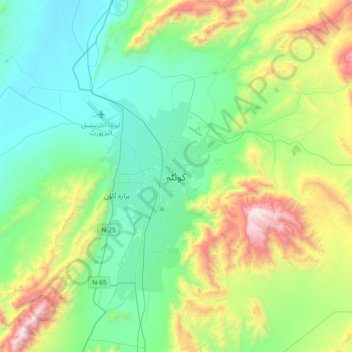
Nombre: Mapa topográfico Quetta, altitud, relieve.
Lugar: Quetta, Mastung District, Balochistan, 87300, Pakistan (30.03574 66.85725 30.35574 67.17725)
Altitud media: 1.968 m
Altitud mínima: 1.538 m
Altitud máxima: 3.180 m
Quetta (Pashto: کوټه Kwaṭa; Balochi: کویته; Hazaragi: کوٹه; Urdu: کوئٹہ; (listen); formerly known as Shalkot (Pashto: شالکوټ) is the provincial capital and largest city of Balochistan, Pakistan. It is also the 10th largest city of Pakistan. It was largely destroyed in the 1935 Quetta earthquake, but was rebuilt and has a population of 1,001,205 according to the census of 2017. Quetta is at an average elevation of 1,680 metres (5,510 feet) above sea level, making it Pakistan's only high-altitude major city. The city is known as the "Fruit Garden of Pakistan," due to the numerous fruit orchards in and around it, and the large variety of fruits and dried fruit products produced there.
Otros mapas topográficos
Haga clic en un mapa para ver su topografía, su altitud y su relieve.
Hanna Lake
Pakistan > Balochistan > Quetta
Hanna Lake, Quetta Road, Cantonment, Quetta, Ziārat District, Balochistan, 87300, Pakistan
Altitud media: 1.957 m