
Mapa topográfico Lincang
Mapa interactivo
Haga clic en el mapa para ver la altitud.
Lincang
Lincang covers latitude 23° 05′-25° 02′ N and longitude 98° 40′-100° 33′ E, thus straddling the Tropic of Cancer in the southern part of its administrative area, or prefecture. It is situated on the middle to lower reaches of the Mekong, known as the Lancang in China, and the Salween, or the Nu. Bordering prefectures are Pu'er to the southeast, and Baoshan and Dali to the northwest. It also borders Burma's Shan State. Elevations within the prefecture range from 450 to 3,504 metres (1,476 to 11,496 ft).
Acerca de este mapa
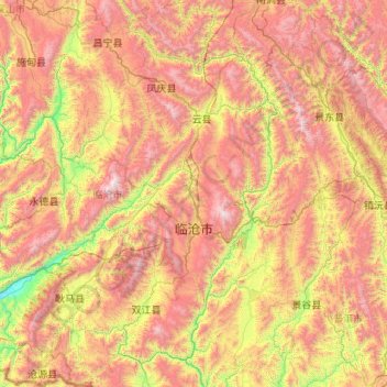
Nombre: Mapa topográfico Lincang, altitud, relieve.
Lugar: Lincang, Yunnan, China (23.07996 98.67345 25.03572 100.54641)
Altitud media: 1.647 m
Altitud mínima: 479 m
Altitud máxima: 3.464 m
Otros mapas topográficos
Haga clic en un mapa para ver su topografía, su altitud y su relieve.
Baihetan Dam
China > Yunnan > Qiaojia County > Zhaotong City > Dazhai
The Baihetan Dam (simplified Chinese: 白鹤滩大坝; traditional Chinese: 白鶴灘大壩; pinyin: Báihètān Dàbà) is a large hydroelectric dam on the Jinsha River, an upper stretch of the Yangtze River in Sichuan and Yunnan provinces, in southwest China. The dam is a 289-meter-tall double-curvature arch…
Altitud media: 1.061 m
Yuanyang
China > Yunnan > Yuanyang County
It covers an area of 2,200 km2 (850 sq mi) and has a population of approximately 365,000 (2002), of which 88% belong to ethnic minorities and 95% is associated with agriculture. The majority of the inhabitants of the county are from the Hani ethnic group. The GDP of Yuanyang county in 2021 was 9,312 million…
Altitud media: 1.171 m
Pu'er
Pu'er is located in southern/southwestern Yunnan, on the lower reaches of the Mekong (known in Chinese as the Lancang), with the bordering prefectures being Yuxi to the northeast, Honghe to the east, Xishuangbanna to the south, Lincang to the northwest, and Dali and Chuxiong. It also shares borders with…
Altitud media: 1.401 m