
Mapa topográfico Rouyn-Noranda
Haga clic en el mapa para ver la altitud.
Acerca de este mapa
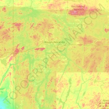
Nombre: Mapa topográfico Rouyn-Noranda, altitud, relieve.
Lugar: Rouyn-Noranda, Abitibi-Témiscamingue, Quebec, Canada (47.70256 -79.51763 48.57496 -78.22118)
Altitud media: 307 m
Altitud mínima: 186 m
Altitud máxima: 563 m
Otros mapas topográficos
Haga clic en un mapa para ver su topografía, su altitud y su relieve.
Gault Nature Reserve
Canada > Quebec > La Vallée-du-Richelieu > Mont-Saint-Hilaire
Altitud media: 189 m
Mount Royal
Canada > Quebec > Urban agglomeration of Montreal > Montreal
The hill is part of the Monteregian Hills situated between the Laurentians and the Appalachian Mountains. It gave its Latin name, Mons Regius, to the Monteregian chain. The hill consists of three peaks: Colline de la Croix (or Mont Royal proper) at 233 m (764 ft), Colline d'Outremont (or Mount Murray, in the…
Altitud media: 111 m
Scouts Canada - Lake Lovering Scouts Reserve
Canada > Quebec > Memphrémagog > Magog
Altitud media: 260 m
Madeleine-Centre
Canada > Quebec > La Haute-Gaspésie > Sainte-Madeleine-de-la-Rivière-Madeleine
Altitud media: 72 m
Forêt Montmorency
Canada > Quebec > La Côte-de-Beaupré > Lac-Jacques-Cartier
Located in the Laurentian Mountains, the Montmorency forest is drained by the Montmorency River and by one of its tributaries, the Black river. There are four lakes: Lac Piché, Bédard, Laflamme and Joncas. The altitude varies between 600 and 1,000 meters (3,300 ft) with an average of 750 meters. The…
Altitud media: 794 m
Mount Royal Park
Canada > Quebec > Urban agglomeration of Montreal > Montreal
The mountain is part of the Monteregian Hills situated between the Laurentians and the Appalachian Mountains. It gave its Latin name, Mons Regius, to the Monteregian chain. The mountain consists of three peaks: Colline de la Croix (or Mont Royal proper) at 233 m (764 ft), Colline d'Outremont (or Mount Murray,…
Altitud media: 110 m
Cap-aux-Meules
Canada > Quebec > Urban agglomeration of Les Îles-de-la-Madeleine > Les Îles-de-la-Madeleine
Altitud media: 13 m
Quebec
Canada > Quebec > Urban agglomeration of Québec
Quebec City was built on the north bank of the Saint Lawrence River, where it narrows and meets the mouth of the Saint-Charles River. Old Quebec is located on top and at the foot of Cap-Diamant, which is on the eastern edge of a plateau called the promontory of Quebec (Quebec hill). Because of this topographic…
Altitud media: 100 m