
Mapa topográfico Mount Royal
Haga clic en el mapa para ver la altitud.
Mount Royal
The hill is part of the Monteregian Hills situated between the Laurentians and the Appalachian Mountains. It gave its Latin name, Mons Regius, to the Monteregian chain. The hill consists of three peaks: Colline de la Croix (or Mont Royal proper) at 233 m (764 ft), Colline d'Outremont (or Mount Murray, in the borough of Outremont) at 211 m (692 ft), and Westmount Summit at 201 m (659 ft) elevation above mean sea level.
Acerca de este mapa
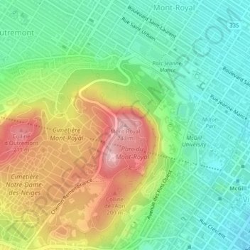
Nombre: Mapa topográfico Mount Royal, altitud, relieve.
Altitud media: 111 m
Altitud mínima: 35 m
Altitud máxima: 232 m
Otros mapas topográficos
Haga clic en un mapa para ver su topografía, su altitud y su relieve.
Parc de la Rive-Boisée
Canada > Quebec > Urban agglomeration of Montreal > Montreal
Altitud media: 29 m
Rosemont–La Petite-Patrie
Canada > Quebec > Urban agglomeration of Montreal > Montreal
Altitud media: 50 m
Le Plateau-Mont-Royal
Canada > Quebec > Urban agglomeration of Montreal > Montreal
Altitud media: 70 m
Parc-nature du Bois-de-Liesse
Canada > Quebec > Urban agglomeration of Montreal > Montreal
Altitud media: 28 m
Parc-nature de la Pointe-aux-Prairies
Canada > Quebec > Urban agglomeration of Montreal > Montreal
Altitud media: 12 m