Geolocalizar

Mapa topográfico Torfaen

Haga clic en el mapa para ver la altitud.

Torfaen

Exterior A large iron framed market hall with two full elevations and three secondary entrances through other street frontages, eg. Jubilee Building, Crane Street. Built of grey narrow coursed rock faced pennant limestone with some larger stones, and with yellow Ebbw Vale brick dressings and a Welsh slate roof. Single storey street elevations with windows onto secondary aisles which surround the main aisled hall. The Market Street elevation has a central doorway with four centred Tudor arch head. This has part glazed wooden doors with pilasters rising to a corbel frieze and a date panel 1893, and a parapet over with raised battlement type features at either end. This door is flanked on either side by four three-light windows with yellow brick frames and mullions. These are all in line, but the plinth below with yellow brick coping is stepped down the street. Additional doors flank these, again with pilasters but not rising to a parapet; then another three light window at the north end but only a single light one at the south corner. The end elevation has first a single light, then a two-light with king mullion, then five three-light windows, the most northerly one with a roundel in a gable above. The roofs behind these walls can be seen stepped up in three heights over the two aisles and the main nave. The nave roof has timber gable windows and glazing along the length of the roof on both slopes. Crane Street entrance: This has another Tudor doorway as above, but flanked by one over one windows in plain heads. Above the entrance is a crow-stepped gable with block at apex and a three light window with stepped head above the door. Gable has date 1894 and inscription PLB (Pontypool Local Board). Commercial Street entrance has another Tudor style doorway set into the ground floor of an early C19 terrace on the south west side of Commercial Street. Only the doorway and the dateplaque 1894 above it are late C19.

Wikipedia (CC-BY-SA 3.0)

Acerca de este mapa

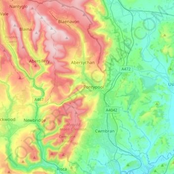
Nombre: Mapa topográfico Torfaen, altitud, relieve.

Lugar: Torfaen, Wales, United Kingdom (51.60667 -3.14392 51.79623 -2.95882)

Altitud media: 206 m

Altitud mínima: 0 m

Altitud máxima: 575 m

Otros mapas topográficos

Haga clic en un mapa para ver su topografía, su altitud y su relieve.

Snowdon

United Kingdom > Wales > Gwynedd

Snowdon (/ˈsnoʊdən/) or Yr Wyddfa (pronounced [ər ˈʊɨ̞̯ðva] (listen)), is the highest mountain in Wales, at an elevation of 1,085 metres (3,560 ft) above sea level, and the highest point in the British Isles outside the Scottish Highlands. It is located in Snowdonia National Park (Parc Cenedlaethol…

Altitud media: 692 m

Newport

United Kingdom > Wales > Newport

Altitud media: 89 m

Cambrian Mountains

United Kingdom > Wales > Powys

Altitud media: 319 m

Tremadog Bay

United Kingdom > Wales

Altitud media: 0 m

Swansea

United Kingdom > Wales > Swansea

Much of Swansea is hilly with the main area of upland being located in the council ward of Mawr. Areas up to 185 metres (607 ft) in elevation range across the central section: Kilvey Hill, Townhill and Llwynmawr separate the centre of Swansea from its northern suburbs. Cefn Bryn, a ridge of high land, is the…

Altitud media: 73 m

Bullwell Bay

United Kingdom > Wales

Altitud media: 14 m

Cardiff

United Kingdom > Wales > Cardiff

Altitud media: 55 m

Wrexham

United Kingdom > Wales > Wrexham

Altitud media: 139 m

Brecon

United Kingdom > Wales > Powys

Altitud media: 216 m

Monmouth

United Kingdom > Wales > Monmouthshire

Altitud media: 101 m

Llanidloes

United Kingdom > Wales > Powys

Altitud media: 267 m

Harlech

United Kingdom > Wales > Gwynedd

Altitud media: 68 m

Trap

United Kingdom > Wales > Carmarthenshire

Altitud media: 185 m

Tallarn Green

United Kingdom > Wales > Wrexham

Altitud media: 53 m

Llanover

United Kingdom > Wales > Monmouthshire

Altitud media: 117 m

Carnedd Dafydd

United Kingdom > Wales > Gwynedd

Altitud media: 714 m

River Conwy

United Kingdom > Wales > Conwy > Pentrefelin

Altitud media: 38 m

Llyn Cowlyd

United Kingdom > Wales > Conwy

Altitud media: 481 m

Llyn Eigiau

United Kingdom > Wales > Conwy > Caerhun

Altitud media: 491 m

Llyn y Fan Fawr

United Kingdom > Wales > Powys > Llywel

Altitud media: 610 m

Swansea Bay

United Kingdom > Wales > Swansea > Mumbles

Altitud media: 25 m

Skokholm

United Kingdom > Wales > Pembrokeshire

Altitud media: 3 m

Caldey Island

United Kingdom > Wales > Pembrokeshire

Caldey Island is about 1.5 miles (2.4 km) long and 1 mile (1.6 km) in width at its widest. It has an area of 538 acres (2.18 km2) and its highest elevation is 197 feet (60 m). The island lies in Carmarthen Bay on the northern side of the Bristol Channel in the county of Pembrokeshire, a little over 2.5 miles…

Altitud media: 5 m

Flat Holm

United Kingdom > Wales > Cardiff

Altitud media: 0 m

Braich y Pwll

United Kingdom > Wales > Gwynedd

Altitud media: 21 m

Moel Hebog

United Kingdom > Wales > Gwynedd > Beddgelert

Altitud media: 439 m

Capel Garmon

United Kingdom > Wales > Conwy

Altitud media: 204 m

Aberystwyth

United Kingdom > Wales > Ceredigion

Aberystwyth experiences an oceanic climate (Köppen climate classification Cfb) similar to almost all of the United Kingdom. This is particularly pronounced due to its west coast location facing the Irish Sea. Air undergoes little land moderation and so temperatures closely reflect the sea temperature when…

Altitud media: 39 m

Abergavenny

United Kingdom > Wales > Monmouthshire

Altitud media: 187 m

Ystrad Meurig

United Kingdom > Wales > Ceredigion

Altitud media: 218 m

Llanelli

United Kingdom > Wales > Carmarthenshire

Altitud media: 41 m

Dolfor

United Kingdom > Wales > Powys

Altitud media: 330 m

Three Crosses

United Kingdom > Wales > Swansea

Altitud media: 82 m

Nantmor

United Kingdom > Wales > Gwynedd

Altitud media: 150 m

Tan-y-groes

United Kingdom > Wales > Ceredigion

Altitud media: 143 m

Caehopkin

United Kingdom > Wales > Powys

Altitud media: 235 m

Meinciau

United Kingdom > Wales > Carmarthenshire

Altitud media: 125 m

Llandrillo

United Kingdom > Wales > Denbighshire

Altitud media: 272 m

Bryneglwys

United Kingdom > Wales > Denbighshire

Altitud media: 319 m

St Asaph

United Kingdom > Wales > Denbighshire

Altitud media: 125 m

Sodom

United Kingdom > Wales > Denbighshire > St Asaph

Altitud media: 129 m

Pennard

United Kingdom > Wales > Swansea

Altitud media: 47 m

Velindre

United Kingdom > Wales > Carmarthenshire > Drefach

Altitud media: 114 m

Cefn Coch

United Kingdom > Wales > Powys

Altitud media: 255 m

Sennybridge

United Kingdom > Wales > Powys

Altitud media: 261 m

Rhoshirwaun

United Kingdom > Wales > Gwynedd

Altitud media: 77 m

Trefnant

United Kingdom > Wales > Denbighshire

Altitud media: 59 m

Glyder Fawr

United Kingdom > Wales > Gwynedd

Altitud media: 671 m

Llyn y Fan Fach

United Kingdom > Wales > Carmarthenshire

Llyn y Fan Fach (Welsh meaning "little lake of the peak") is a lake of approximately 10 hectares (25 acres) on the northern margin of the Black Mountain in Carmarthenshire, South Wales and lying within the Brecon Beacons National Park. The lake lies at an altitude of approximately 1,660 feet (510 m),…

Altitud media: 549 m

Y Bontuchel

United Kingdom > Wales > Denbighshire

Altitud media: 202 m

Cynwyd

United Kingdom > Wales > Denbighshire

Altitud media: 246 m

Rhuallt

United Kingdom > Wales > Denbighshire

Altitud media: 134 m

Llanynys

United Kingdom > Wales > Denbighshire

Altitud media: 56 m

Lightwood Green

United Kingdom > Wales > Wrexham

Altitud media: 62 m

Forden

United Kingdom > Wales > Powys

Altitud media: 103 m

Cefn

United Kingdom > Wales > Powys

Altitud media: 139 m

Llechwedd

United Kingdom > Wales > Conwy

Altitud media: 366 m

Llanwrtyd Wells

United Kingdom > Wales > Powys

Altitud media: 296 m

Shirenewton

United Kingdom > Wales > Monmouthshire

Altitud media: 108 m

Crossgates

United Kingdom > Wales > Powys

Altitud media: 225 m

St Harmon

United Kingdom > Wales > Powys

Altitud media: 334 m

Llanrhos

United Kingdom > Wales > Conwy > Conwy

Altitud media: 29 m

Hope

United Kingdom > Wales > Flintshire

Altitud media: 117 m

Upper Loughor

United Kingdom > Wales > Swansea > Gorseinon

Altitud media: 18 m

Brynna

United Kingdom > Wales > Rhondda Cynon Taf

Altitud media: 109 m

Llandudno Junction

United Kingdom > Wales > Conwy

Altitud media: 60 m

Rhiwderin

United Kingdom > Wales > Newport

Altitud media: 73 m

Skewen

United Kingdom > Wales > Neath Port Talbot

Altitud media: 57 m

Wernffrwd

United Kingdom > Wales > Swansea > Crofty

Altitud media: 32 m

Tal-y-bont

United Kingdom > Wales > Gwynedd

Altitud media: 60 m

Blorenge

United Kingdom > Wales > Monmouthshire > Govilon

Altitud media: 394 m

Bwlchllan

United Kingdom > Wales > Ceredigion

Altitud media: 186 m

Aberbeeg

United Kingdom > Wales > Blaenau Gwent

Altitud media: 292 m