
Mapa topográfico Snake River
Mapa interactivo
Haga clic en el mapa para ver la altitud.
Acerca de este mapa
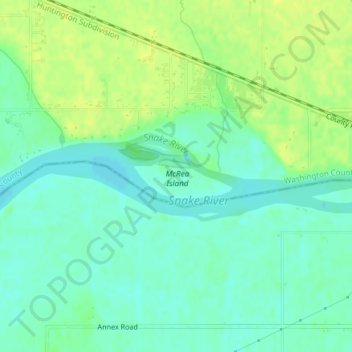
Nombre: Mapa topográfico Snake River, altitud, relieve.
Altitud media: 644 m
Altitud mínima: 635 m
Altitud máxima: 653 m
Mountain ranges in the Snake watershed include the Teton Range, Bitterroot Range, Clearwater Mountains, Seven Devils Mountains, and the extreme northwestern end of the Wind River Range. Grand Teton is the highest point in the Snake River watershed, reaching 13,775 feet (4,199 m) in elevation. The elevation of the Snake River is 358 feet (109 m) when it joins the Columbia River.
Otros mapas topográficos
Haga clic en un mapa para ver su topografía, su altitud y su relieve.
Sawtooth National Forest
United States of America > Idaho > Rupert
Sawtooth National Forest, Sharon Court, Rupert, Minidoka County, Idaho, 83350, United States of America
Altitud media: 1.608 m
Genesee
United States of America > Idaho > Genesee
Genesee, Latah County, Idaho, 83832, United States of America
Altitud media: 824 m
Butte County
United States of America > Idaho
Butte County, Idaho, United States of America
Altitud media: 1.914 m
Chinese Peak
United States of America > Idaho
Chinese Peak, Bannock County, Idaho, United States of America
Altitud media: 1.830 m
Camas County
United States of America > Idaho
Camas County, Idaho, United States of America
Altitud media: 2.002 m
Eagle Rock
United States of America > Idaho
Eagle Rock, Idaho County, Idaho, United States of America
Altitud media: 1.164 m
Teton
United States of America > Idaho > Teton
Teton, Fremont County, Idaho, 83451, United States of America
Altitud media: 1.509 m
Springston
United States of America > Idaho
Springston, Kootenai County, Idaho, 83833, United States of America
Altitud media: 721 m