
Mapa topográfico Beattock
Mapa interactivo
Haga clic en el mapa para ver la altitud.
Acerca de este mapa
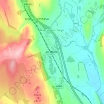
Nombre: Mapa topográfico Beattock, altitud, relieve.
Altitud media: 144 m
Altitud mínima: 80 m
Altitud máxima: 257 m
Otros mapas topográficos
Haga clic en un mapa para ver su topografía, su altitud y su relieve.
Newton
United Kingdom > Scotland > Dumfries and Galloway
Newton, Dumfries and Galloway, Scotland, DG10 9NX, United Kingdom
Altitud media: 117 m
Kirkton
United Kingdom > Scotland > Dumfries and Galloway
Kirkton, Dumfries and Galloway, Scotland, DG1 1WD, United Kingdom
Altitud media: 24 m
Calfield
United Kingdom > Scotland > Dumfries and Galloway > Langholm > Becks
Calfield, Becks, Langholm, Dumfries and Galloway, Scotland, DG13 0LP, United Kingdom
Altitud media: 204 m
Closeburn
United Kingdom > Scotland > Dumfries and Galloway
Closeburn, Dumfries and Galloway, Scotland, DG3 5HT, United Kingdom
Altitud media: 81 m